The fmc determines and update present aircraft position from the following ? [ Exercise lift off ]
Question 57-1 : 1 2 3 1 2 4 1 2 3 4 3
 1, 2, 3.
 The fmc determines and update present aircraft position from the following ?
Question 57-2 : 2 3 4 1 2 4 2 4 1 3
 2, 3, 4.
 The fms enables to fly an optimum flight profile for this the fmc flight ?
Question 57-3 : 1 2 3 5 1 2 5 2 3 4 1 3 5
 1, 2, 3, 5.
 The fms flight plan or leg page displays the following parameters relative to ?
Question 57-4 : 2 3 4 1 3 4 1 2 1 2 3 4
 2, 3, 4.
 The fms provides the following functions .1 traffic advisories emission.2 ?
Question 57-5 : 3 4 1 3 4 1 2 3 1 4
 3, 4.
3, 4. The fms flight plan or leg page displays the following parameters relative to ?
Question 57-6 : 1 4 1 3 3 4 1 2 4
 1, 4.
1, 4. For most fms the fuel prediction function which computes the remaining fuel ?
Question 57-7 : 2 1 3 2 4 3
For most fms the fuel prediction function which computes the remaining fuel ?
Question 57-8 : 4 1 4 3 3 1 2
 4.
4. The duration of a fms navigation database loaded before expiring is ?
Question 57-9 : 28 days 15 days 2 months 3 months
The role of the fms is to .1 aid the crew with navigation.2 shut down the ?
Question 57-10 : 1 4 5 2 3 4 5 1 2 3 1 3 4
 1, 4, 5.
 The role of the fms is to aid the flight crew with .1 immediate actions in ?
Question 57-11 : 2 3 2 3 4 3 4 1 2
 2, 3.
2, 3. In a fms mcdus are used pre flight to manually initialise with dispatch ?
Question 57-12 : 1 4 2 1 3 2 3 4
 1, 4.
1, 4. The 'overfly' symbol related to a waypoint on an fms page indicates that ?
Question 57-13 : The aircraft is required to pass directly over this waypoint a time estimate is given for this waypoint a turn anticipation is permited a fuel prediction is given for this waypoint
 The aircraft is required to pass directly over this waypoint.
 The fms required time of arrival rta function can provide ?
Question 57-14 : A speed target to satisfy a time constraint entered at a flight plan waypoint a time slot computed for the arrival time at destination using the current aircraft speed and speed constraints along the flight plan a time prediction at the active to waypoint complying with the wind computation a time prediction at the flight plan waypoints based on the current speed and speed constraints along the flight plan
 A speed target to satisfy a time constraint entered at a flight plan waypoint.
 The fuel management performed by most fms along the flight plan is considered as ?
Question 57-15 : A function which helps the crew to estimate the remaining fuel quantity along the flight plan but should not be considered as an accurate and reliable source an accurate function which can be considered as the prime source to determine the remaining fuel quantity along the flight plan an accurate and very reliable function providing that the fuel on board quantity has been properly initialized by the crew before start up the prime source to manage the fuel consumption along the flight
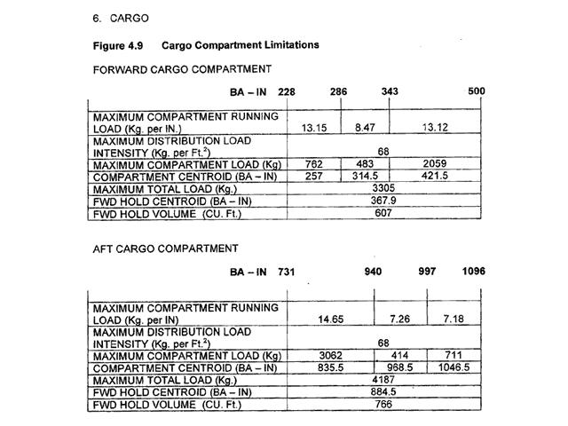 A function which helps the crew to estimate the remaining fuel quantity along the flight plan but should not be considered as an accurate and reliable source.
 Some of the fms have a navigation mode called dead reckoning mode dr computing ?
Question 57-16 : A back up navigation mode to compute a fms position when the other navigation sensors are no longer operating an operating mode used to intercept radials to or from a flight plan waypoint a navigation mode used to monitor the fms position the normal navigation mode for fms which do not use inertial navigation systems ins to compute the aircraft position
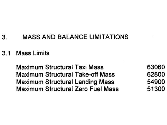 A back up navigation mode to compute a fms position when the other navigation sensors are no longer operating.
 The fms lateral offset function consists in ?
Question 57-17 : Flying along the flight plan legs with a constant right or left offset manually entered on the fms cdu displaying the lateral cross track deviation xtk of the aircraft according to the active flight plan leg creating a new waypoint using a reference flight plan waypoint and a distance from this waypoint along the flight plan legs flying a fms selected lateral pattern used for search and rescue operations
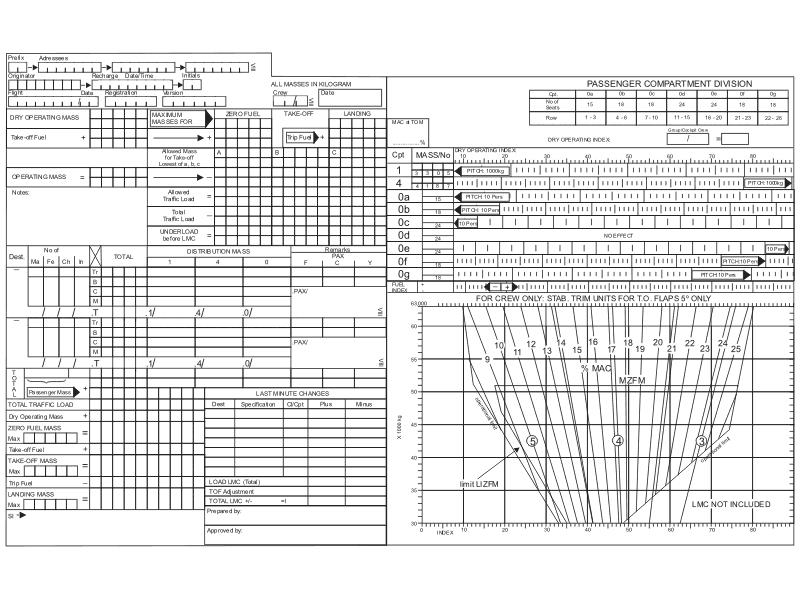 Flying along the flight plan legs with a constant right or left offset manually entered on the fms cdu.
 The fms navigation database includes the following data .1 airports.2 ?
Question 57-18 : 1 3 4 1 2 3 2 5 1 3 4 5
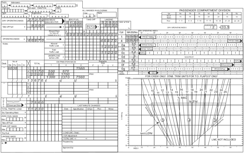 1, 3, 4.
 The most common sensors interfacing a fms to compute the aircraft position ?
Question 57-19 : 1 3 1 2 3 2 3 1 4
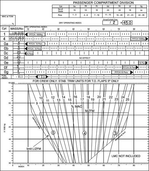 1, 3.
1, 3. For a fms designed with the vertical navigation vnav capability coupled to the ?
Question 57-20 : 2 3 1 2 1 3 2
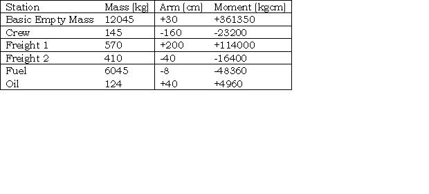 2, 3.
2, 3. The fms navigation database includes the following data .1 obstacles.2 ?
Question 57-21 : 2 3 4 5 1 2 3 4 5 1 2 4 1 3 5
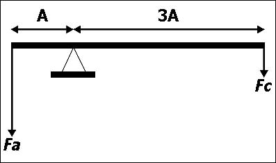 2, 3, 4, 5.
 The fms provides the following functions .1 aid for fuel management.2 lateral ?
Question 57-22 : 1 2 4 1 2 3 2 3 3 4
The fms cross track xtk is ?
Question 57-23 : The abeam distance error to the left or right from the desired flight plan leg to the aircraft position the angular distance error to the left or right from the desired track dtk to the aircraft track tk the distance error between the fms computed position and the irs computed position the distance error between the fms computed position and the gps computed position
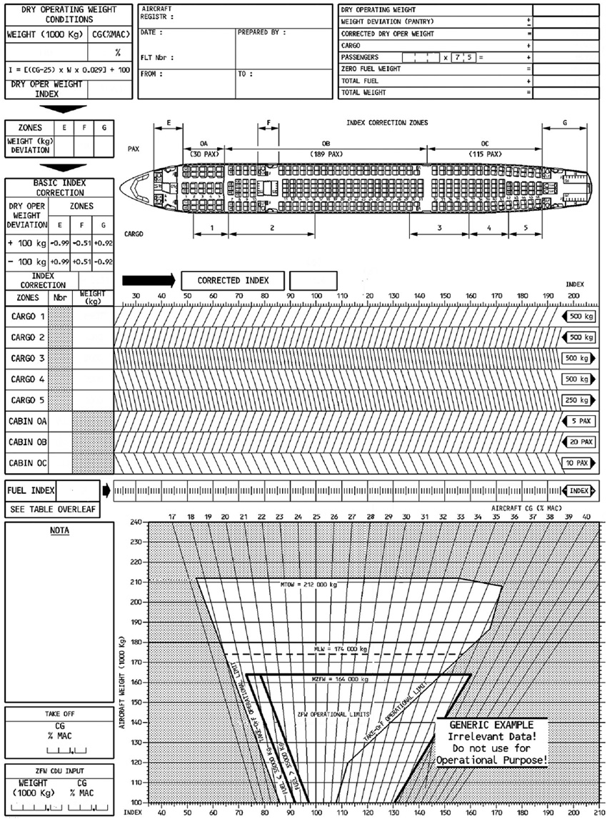 The abeam distance error, to the left or right from the desired flight plan leg to the aircraft position.
 The fms vertical navigation management is generally performed based on ?
Question 57-24 : The baro altitude input from the adc the gps altitude computed by the gps receiver a mix of baro and gps altitudes the geometric altitude input from the terrain awareness and warning system taws
The fms navigation database includes the following data .1 airports.2 take ?
Question 57-25 : 1 3 5 1 2 3 3 4 5 1 2 5
 1, 3, 5.
 In a dual fms architecture when an incompatibility between the two fmc's occurs ?
Question 57-26 : Both fmc's are working independently they are linked only to their own peripherals only the left one remains active only the right one remains active they will have to be disconnected
 Both fmc's are working independently: they are linked only to their own peripherals.
 Considering a two fms architecture working in dual mode . fmc flight management ?
Question 57-27 : One fmc is stated as 'master' the other as 'slave' both fmc are synchronized via an exchange bus a fmc is used by the captain the other by the copilot the fmc are not synchronized only one fmc feeds the two fms the main fmc is working the other on standby in the event of a failure of the 'master' fmc
 One fmc is stated as 'master', the other as 'slave'; both fmc are synchronized via an exchange bus.
 The component used to enter the flight plan route on the fms is the ?
Question 57-28 : Mcdu cmu fmc lcd
 Mcdu.
Mcdu. The database of a fms flight management system is divided into major sections ?
Question 57-29 : Aircraft performance and navigation navigation and meteorology aircraft performance and fuel saving inertial and navigation
 Aircraft performance and navigation.
 For most fms the fuel prediction function which computes the remaining fuel ?
Question 57-30 : 2 4 1 2 3 4 1 3 1 2 4
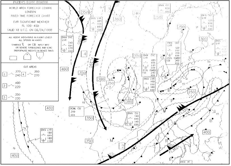 2, 4.
2, 4. Under normal conditions in a dual fms architecture the master fmc sends its ?
Question 57-31 : Autopilot flight director and autothrottle flight director and autothrottle autopilot and autothrottle autopilot
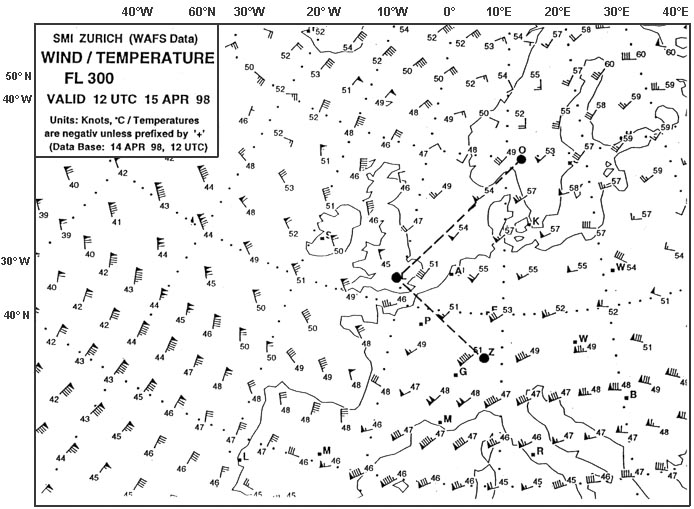 Autopilot, flight director and autothrottle.
 The purpose of the flight management system fms is to provide ?
Question 57-32 : Continuous automatic navigation guidance and performance management continuous automatic navigation guidance as well as manual performance management manual navigation guidance and automatic performance management both manual navigation guidance and performance management
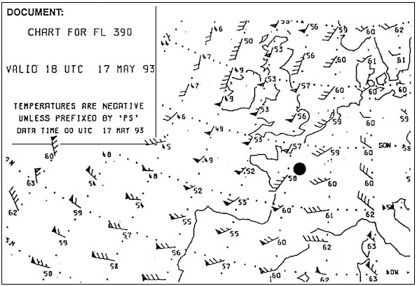 Continuous automatic navigation guidance and performance management.
 A fms can correct its fuel computations for the following non standard ?
Question 57-33 : 3 1 2 4 2 3 4 1
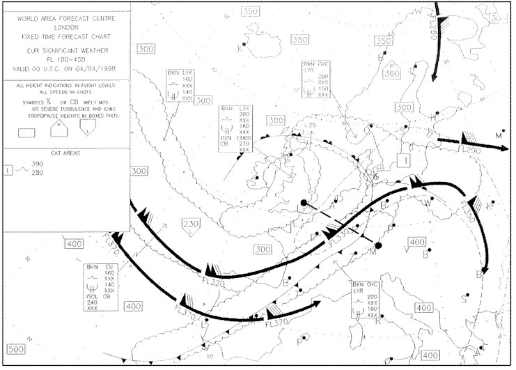 3.
3. The fms 'autotune' function can automatically tune frequencies for ?
Question 57-34 : Vor and dme navaids vhf and hf radio navaids and vhf radio vhf radio only
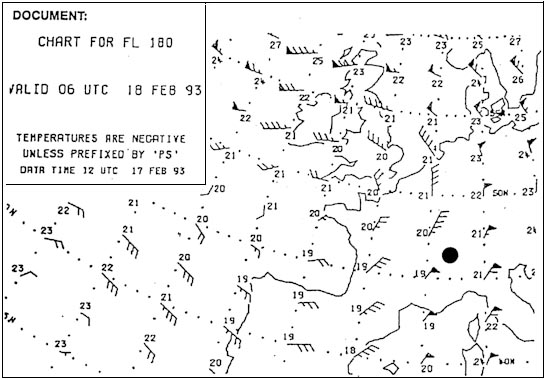 Vor and dme.
 In order to enter a phantom waypoint that is designated by a vor/dme simple ?
Question 57-35 : Does not have to be in range when entered but must be when used does not have to be in range when entered or used must be in range has to be positively identified by one of the pilots
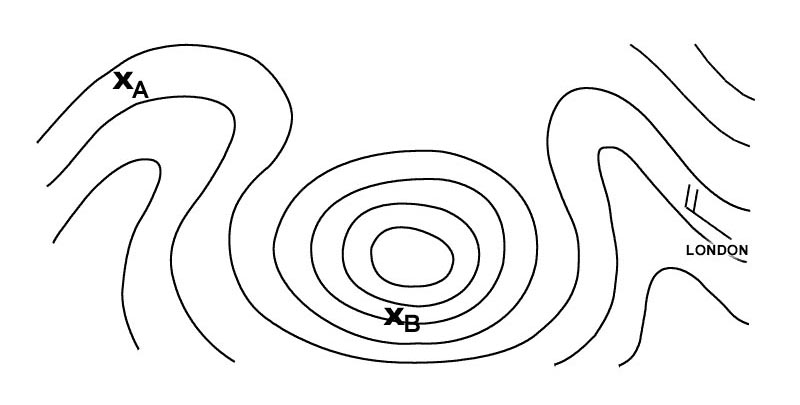 Does not have to be in range when entered but must be when used.
 Which of the following combinations is likely to result in the most accurate ?
Question 57-36 : Dme/dme vor/dme ndb/vor vor/vor
 Dme/dme.
 Which of the following gives the best information about the progress of a ?
Question 57-37 : Eto etd ata elapsed time on route
 Eto.
Eto. If an aircraft flies along a vor radial it will follow a ?
Question 57-38 : Great circle track rhumbline track line of constant bearing constant magnetic track
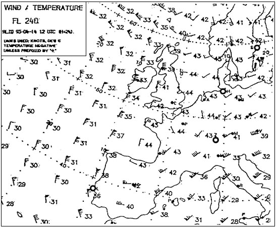 Great circle track.
 Which of the figures depicts an electronic flight instrument system efis ?
Question 57-39 : Figure 1 figure 4 figure 2 figure 3
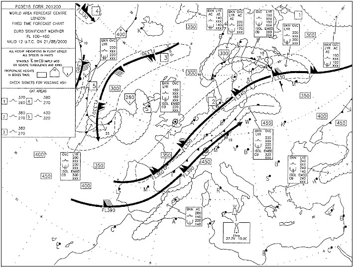 Figure 1.
 Which of the figures depicts an electronic flight instrument system efis ?
Question 57-40 : Figure 4 figure 1 figure 3 figure 2
 Figure 4.
 ~
Exclusive rights reserved. Reproduction prohibited under penalty of prosecution.
2239 Free Training Exam
