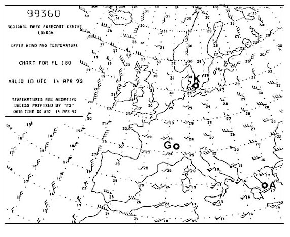
If a flight at fl 150 is planned which of these upper wind and temperature ? [ MCQ aircraft ]
Question 156-1 : 600 hpa 500 hpa 850 hpa 700 hpa
 600 hpa.
 For the planning of a flight with an estimated time of departure 0930 local ?
Question 156-2 : Visual vis and infrared ir polar orbiting system infrared ir geo stationary system water vapour wv geo stationary system infrared ir and water vapour wv polar orbiting system
 Visual (vis) and infrared (ir), polar orbiting system.
 Which constant pressure chart is standard for fl 140 ?
Question 156-3 : 600 hpa 700 hpa 850 hpa 500 hpa
 600 hpa.
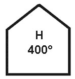
 Which of the following constant pressure charts would be most relevant for ?
Question 156-4 : 400 hpa 600 hpa 300 hpa 500 hpa
 400 hpa.
 Runway visual range is calculated from values derived from ?
Question 156-5 : Forward scatter meters psychrometers ceilometers pluviometers
 Forward-scatter meters.
 Which of the following messages should be cancelled when the conditions are no ?
Question 156-6 : Aerodrome warning trend forecast taf gamet
 Aerodrome warning.
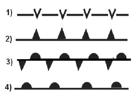
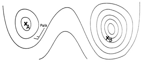
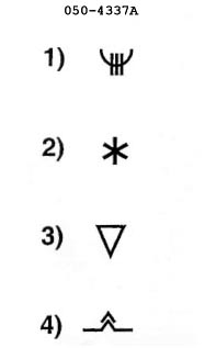
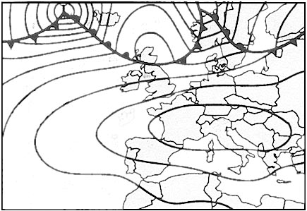
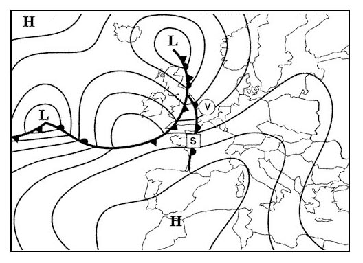
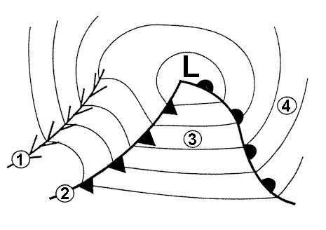
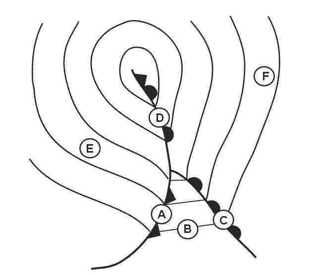
 Which of the following symbols represents a quasi stationary front . 383 ?
Question 156-7 : Symbol 3 symbol 2 symbol 1 symbol 4
 Symbol 3.
 Which kind of meteorological messages are normally transmitted in an atis ?
Question 156-8 : Met report / special taf / speci airmet / gamet metar / speci
 Met report / special
 What is the meaning of the different coloured areas on a plan position ?
Question 156-9 : Different ranges of intensities of precipitation different ranges of cloud thickness vertical extent different horizontal dimensions of clouds different intensities of turbulence light moderate severe within clouds
 Different ranges of intensities of precipitation.
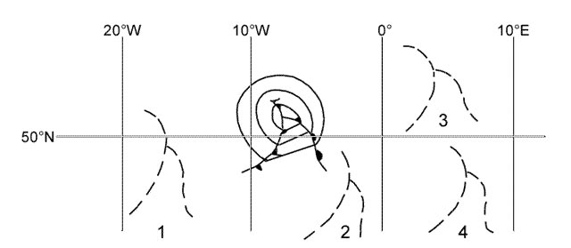
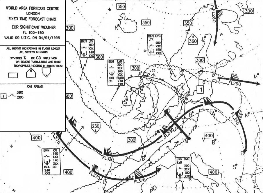
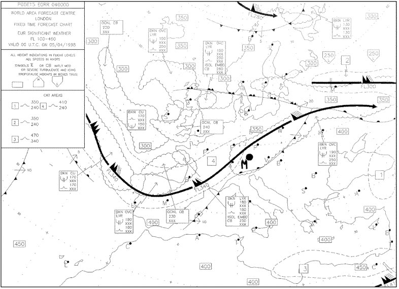
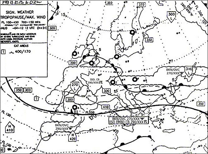
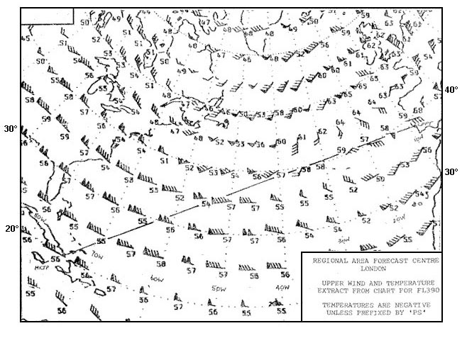
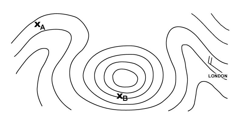
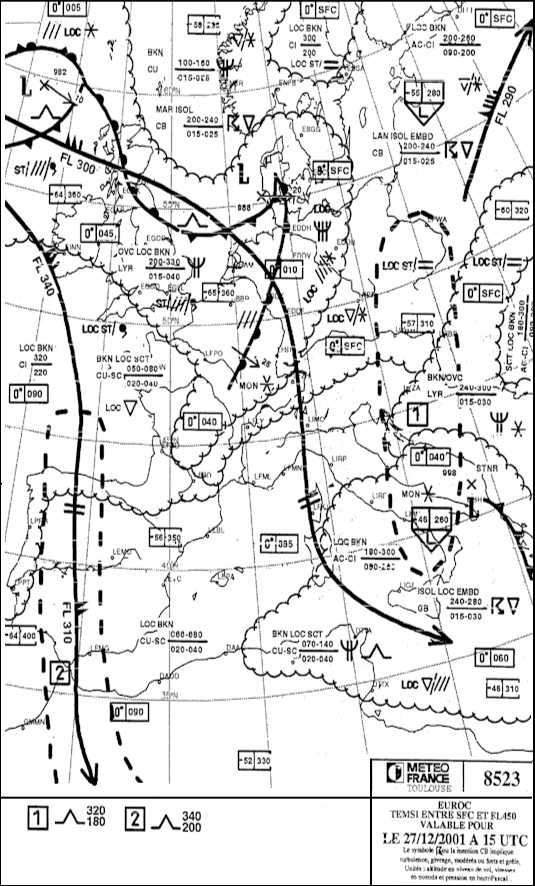
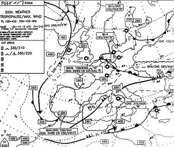
 What name is given to the jet stream lying over scandinavia c . 385 ?
Question 156-10 : Polar front jet stream tropical jet stream subtropical jet stream low level jet stream
 Polar front jet stream.
 Below is the forecast for the destination of a flight whose eta is 2030 utc ?
Question 156-11 : Has to be considered as closed still open until 2200 utc because the weather change is not completed before 2200 utc open the whole night because 300 m of visibility corresponds to at least 900 m rvr still open because the decrease of the visibility below the cat ii minima will be a little bit later than 2030 utc
 Has to be considered as closed.
 A flight with a jet aeroplane from munich to london is planned with a departure ?
Question 156-12 : Infrared ir polar orbiting visual vis geo stationary water vapour wv geo stationary or polar orbiting visual vis polar orbiting
 Infrared (ir), polar orbiting.
 What is a volmet broadcast ?
Question 156-13 : Provision as appropriate of current metar speci taf and sigmet by means of continuous and repetitive voice broadcast weather information transmitted continuously via radio special broadcast containing weather information for one airport that part of an atis which is concerned to meteorological information information issued by a meteorological watch office concerning the occurrence or expected occurrence of specified enroute weather phenomena which may affect the safety of aircraft operations
 Provision, as appropriate, of current metar, speci, taf and sigmet by means of continuous and repetitive voice broadcast.
 Which of the following statements concerning the use of airborne weather radar ?
Question 156-14 : Accurate assessment of the weather ahead of the aircraft might be hampered due to the attenuation of the radar echoes by heavy rain the radar reflectivity echoes are much more determined by the number of reflecting particles than by the particle size the antenna tilt shall be adjusted in order to receive the most significant echoes generally received from an altitude of approximately 30000 ft the most significant echoes will be received due to lightning discharges near the freezing level
 Accurate assessment of the weather ahead of the aircraft might be hampered due to the attenuation of the radar echoes by heavy rain.
 An aircraft encounters atmospheric conditions in which abrupt changes of ?
Question 156-15 : Special air report no air report is necessary flight safety report routine air report
 Special air-report.
 What is the meaning of the following weather message .cnl ws wrng 1 ?
Question 156-16 : The first wind shear warning on the 21st of that month issued at 1130 utc has been cancelled at the same day at 1330 utc the first wind shear warning on the 21st of that month with an occasional intensity has a forecast validity from 1130 until 1330 utc the weather warning with the number 121 concerning a cyclone at low levels has a validity time from 1130 until 1330 utc this message cancels all weather warnings issued on the 21st of january between 1130 and 1330 utc
 The first wind shear warning on the 21st of that month, issued at 1130 utc has been cancelled at the same day at 1330 utc.
 Which interpretation of the following message is correct .lfld ad wrng 1 valid ?
Question 156-17 : It is forecast that some parts of the surface vehicles and aircraft parked outside will be contaminated by hoar frost between 0430 and 0900 on the 5th of that month it is forecast for the period between 0430 and 0900 on the 5th of that month that especially an aircraft in the final approach phase will be covered by hoar frost it is forecast for the period between 0430 and 0900 on the 5th of that month that a departing or arriving aircraft will pass a layer of ground fog in which the aircraft will be contaminated by hoar frost the aerodrome warning for runway 05 due to frost issued at 0430 utc has been cancelled at 0900 utc
 It is forecast that some parts of the surface, vehicles, and aircraft parked outside will be contaminated by hoar frost between 0430 and 0900 on the 5th of that month.
 What is the meaning of 'rera' in a metar ?
Question 156-18 : There has been moderate or heavy rain since the last issue of metar there is showery precipitation in the vicinity it is presently not raining but there has been rain 2 hours ago the intensity of rain is decreasing retrograding rain
 There has been moderate or heavy rain since the last issue of metar.
 Which of these statements about weather satellites are correct or incorrect .1 ?
Question 156-19 : 1 is incorrect and 2 is correct 1 and 2 are correct 1 is correct and 2 is incorrect 1 and 2 are incorrect
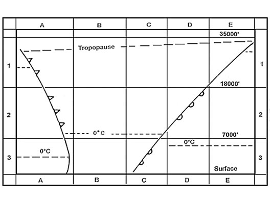 1 is incorrect and 2 is correct.
 Which pilots are obliged to transmit a special air report if they encounter ?
Question 156-20 : All categories of pilots only pilots with atpl or ir only pilots with atpl or ir or cpl only pilots with cpl or ppl
 All categories of pilots.
 Which of the following groups of conditions requires a crew to transmit a ?
Question 156-21 : Severe turbulence widespread thunderstorms severe mountain waves moderate aircraft icing severe turbulence embedded thunderstorms heavy wind shears moderate or severe aircraft icing moderate or severe turbulence volcanic ash cloud isolated thunderstorms moderate or severe sandstorms
 Severe turbulence, widespread thunderstorms, severe mountain waves.
 To which type of message does the following text belong . valid 211600/212000 ?
Question 156-22 : Aerodrome warning sigmet snowtam supplementary information of a metar
 Aerodrome warning.
 For subsonic cruising levels a sigmet is not issued in case of ?
Question 156-23 : Isolated cb severe turbulence volcanic ash heavy sandstorm
 Isolated cb.
 What is a radiosonde ?
Question 156-24 : Instrument intended to be carried by a balloon up through the atmosphere equipped with devices to measure meteorological variables and provided with a radio transmitter for sending this information to the observing station equipment used for determining upper winds only velocity and direction by tracking a free balloon by electronic means at the observing station equipment used for determining upper winds velocity and direction by transmitting different radio waves and measuring the amount of the reflected waves by the moving air these values correlate to the speed and direction of the wind a meteorological station on ground or water at which measurements of meteorological variables are made automatically and a radio transmitter sends automatically this information to a meteorological centre
 Instrument intended to be carried by a balloon up through the atmosphere, equipped with devices to measure meteorological variables and provided with a radio transmitter for sending this information to the observing station.
 A special air report ?
Question 156-25 : May trigger a sigmet message may be the reason for closing an airport due to meteorological conditions may be the reason for closing a part of an airway due to meteorological conditions is used to produce better aerodrome forecasts taf
 May trigger a sigmet message.
 A special air report must be made whenever an aircraft encounters a ?
Question 156-26 : Volcanic ash cloud temperature inversion snow storm dense fog
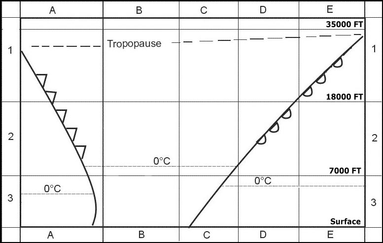 Volcanic ash cloud.
 Which of the following documents should contain forecats for the location and ?
Question 156-27 : Sigmet notam metar taf
 Sigmet.
 What is the defined upper level of the ws wind shear activity in the following ?
Question 156-28 : 1600 ft above runway level 1800 ft above runway level 2000 ft above circling altitude 1000 ft above circling altitude
 1600 ft above runway level.
 Which statement about the content of continuous volmet messages vhf and ?
Question 156-29 : Both types of volmet messages shall contain trend forecasts where available a continuous volmet contains information from the taf tafs are included in both volmet messages forecast information e g a trend or taf is prohibited in volmets
 Both types of volmet messages shall contain trend forecasts where available.
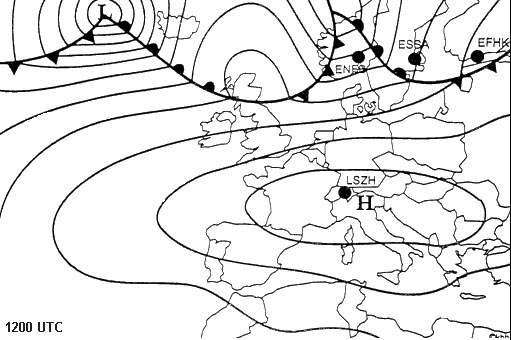
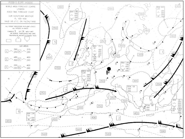
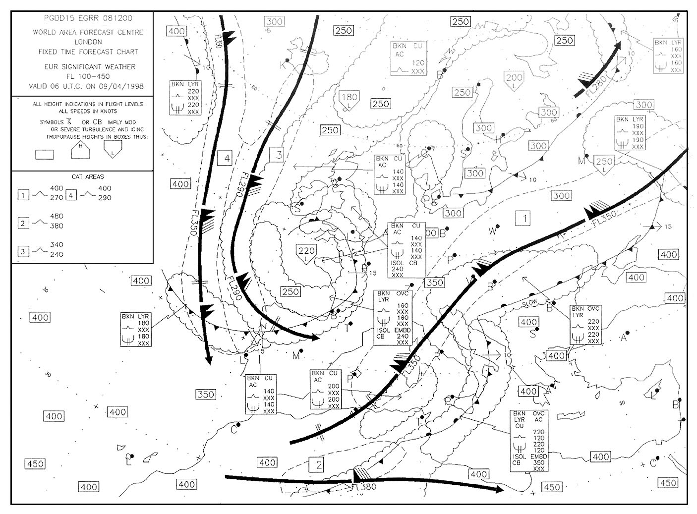
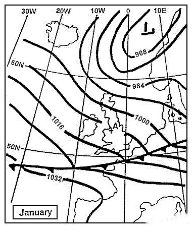
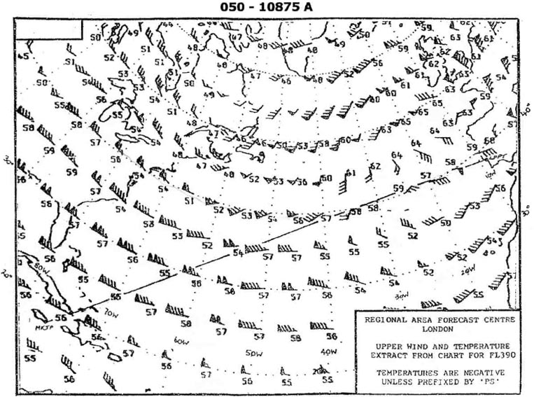
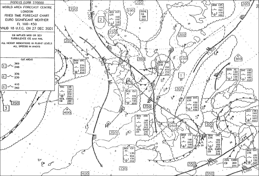
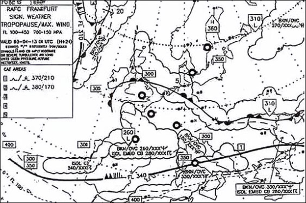
 Which of these statements is true . 396 ?
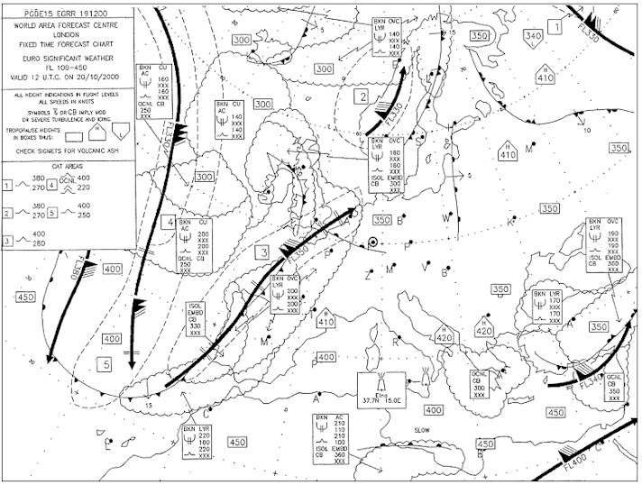
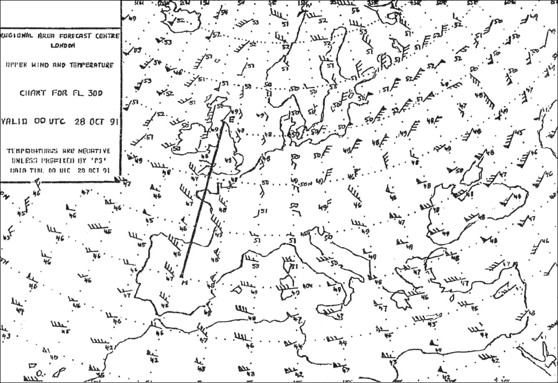
Question 156-30 : Local snow and severe aircraft icing can be expected over germany freezing level above london egll is higher than fl 65 turbulence is likely to be encountered at fl 400 over malaga lemg the front to the east of paris lfpo is moving south
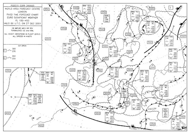 Local snow and severe aircraft icing can be expected over germany.
 When the sky is overcast what means are used by meteorological services for ?
Question 156-31 : Radiosondes satellites diffusionmeters ceiling balloon and theodolite
 Radiosondes.
 Which instrument is used for measuring atmospheric humidity ?
Question 156-32 : Psychrometer anemometer transmissometers ceilometers
 Psychrometer.
 The visibility transmitted in a metar is ?
Question 156-33 : The value that is reached or exceeded within at least half the horizon circle on the aerodrome given by transmissometer when the visibility is below 1500 metres the lowest observed in a 360° scan from the meteorological station b the maximum determined by a meteorologist in a 360° scan at the horizon
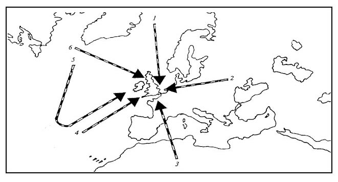 The value that is reached or exceeded within at least half the horizon circle on the aerodrome.
 Which of the following metars reflect the weather conditions expected at ?
Question 156-34 : 21014kt 5000 ra bkn015 ovc030 15/12 q1011 nosig= 19022g46kt 1200 +tsgr bkn003 bkn015 17/14 q1014 becmg nsw= 28010kt 9999 bkn030 22/11 q1016 nosig= vrb03kt 8000 bkn280 19/12 q1012 becmg 3000 br=
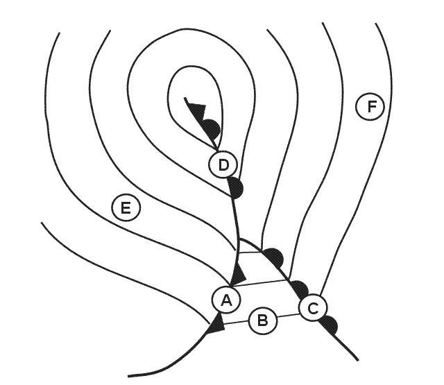 21014kt 5000 ra bkn015 ovc030 15/12 q1011 nosig=
 Which of these statements about weather satellites are correct or incorrect .1 ?
Question 156-35 : 1 is correct 2 is correct 1 is incorrect 2 is correct 1 is correct 2 is incorrect 1 is incorrect 2 is incorrect
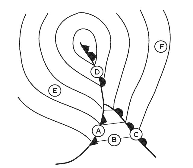 1) is correct, 2) is correct.
 The correct interpretation for the message below is .mod ws rwy 16 fcst = ?
Question 156-36 : Wind shear between runway 16 level and and 1600 ft above that level wind shear between runway 16 level and and 2500 ft above that level wind shear 1000 ft above runway 16 circling approach wind shear 2000 ft above minimal altitude for runway 16 circling approach
 Wind shear between runway 16 level and and 1600 ft above that level.
 A meteorological briefing is ?
Question 156-37 : An oral commentary on existing and/or expected meteorological conditions printed documents constituting a flight record an oral commentary on weather forecasts careful reading of the meteorological elements available for the planned flight
 An oral commentary on existing and/or expected meteorological conditions.
 An aircraft encounters severe turbulence the pilot must ?
Question 156-38 : Issue a special air report message issue a routine air report message issue a safety message issue a report at destination
 Issue a special air-report message.
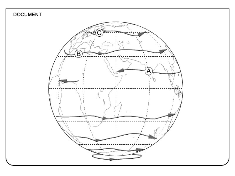
 The angle between the true great circle track and the true rhumb line track ?
Question 156-39 : 7 8° 9° 15 6° 5 2°
 7.8°.
7.8°. In order to fly from position a 10°00'n 030°00'w to position b 30°00'n ?
Question 156-40 : A rhumb line track the constant average drift route the great circle route a straight line plotted on a lambert chart
 A rhumb line track.
 ~
Exclusive rights reserved. Reproduction prohibited under penalty of prosecution.
6199 Free Training Exam
