Un compte Premium offert sur le site FCL.055 ! Rendez-vous sur www.fcl055-exam.fr puis créez un compte avec le même email que celui...   [Lire la suite]


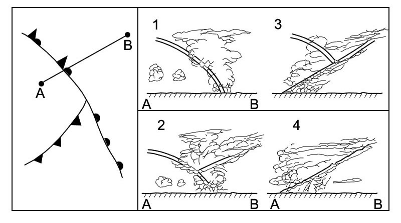
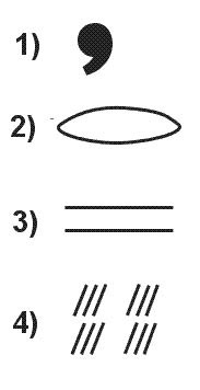
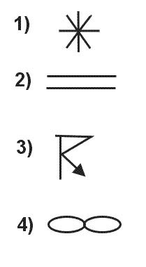
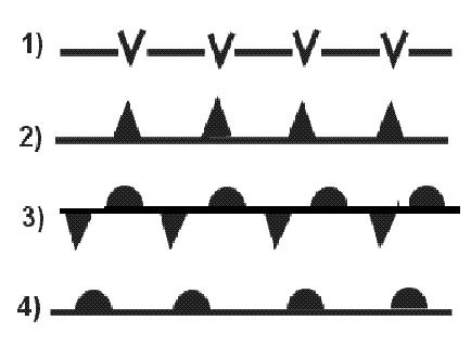
Which one of the displayed cloud forms is representative of a cumulus 375 ?

Revision > flight

exemple reponse 250


Which one of the following cloud types can be characterised by the optical phenomenon called halo ?

exemple reponse 251
Which one of following cloud types can be characterised the optical phenomenon called halo they are produced the ice crystals in cirrus clouds high the particular shape orientation of crystals responsible the type of halo observed light reflected refracted the ice crystals may split up into colors because of dispersion the crystals behave like prisms mirrors refracting reflecting sunlight between their faces sending shafts of light in particular directions.

Which cloud type genus is described by the following definition 'Greyish or bluish cloud sheet or layer of striated fibrous or uniform appearance totally or partly covering the sky and having parts ?

exemple reponse 252
Which cloud type genus described the following definition 'greyish or bluish cloud sheet or layer of striated fibrous or uniform appearance totally or partly covering sky and having parts thin enough to reveal s at least vaguely as through ground glass this genus does not show halo phenomena' cirrus (ci) detached clouds in form of white dedicate filaments or white or mostly white patches or narrow bands these clouds have fibrous (hair like) appearance or a silky sheen or both cirrocumulus (cc) thin white patch sheet or layer of cloud without shading composed of very small elements in form of grains ripples etc merged or separate more or less regularly arranged most of elements have an apparent width of less than one degree cirrostratus (cs) transparent whitish cloud veil of fibrous (hair like) or smooth appearance totally or partly covering sky generally producing halo phenomena altostratus (as) greyish or bluish cloud sheet or layer of striated fibrous or uniform appearance totally or partly covering sky having parts thin enough to reveal sun at least vaguely as through ground glass altostratus cloud does not show halo phenomena altocumulus (ac) white or grey or both white grey patch sheet or layer of cloud generally with shading composed of laminae rounded masses rolls etc which are sometimes partly fibrous or diffuse which may or may not be merged most of regularly arranged small elements usually have an apparent width of between one five degrees nimbostratus (ns) grey cloud layer often dark appearance of which rendered diffuse more or less continuously falling rain or snow which in most cases reaches ground it thick enough throughout to blot out sun stratocumulus (sc) grey or whitish or both grey whitish patch sheet or layer of cloud which almost always has dark parts composed of tessellations rounded masses rolls etc which are non fibrous (except virga) which may or may not be merged most of regularly arranged small elements have an apparent width of more than five degrees stratus (st) generally grey cloud layer with a fairly uniform base which may give drizzle ice prisms or snow grains when sun visible through cloud its outline clearly discernible stratus does not produce halo phenomena except possible at very low temperatures cumulus (cu) detached clouds generally dense with sharp outlines developing vertically in form of rising mounds domes or towers of which bulging upper parts often resembles a cauliflower the sunlit parts of these clouds are mostly brilliant white their base relatively dark nearly horizontal cumulonimbus (cb) heavy dense cloud with a considerable vertical extent in form of a mountain or huge towers at least part of its upper portion usually smooth or fibrous or striated nearly always flattened this part often spreads out in shape of an anvil or vast plume under base of this cloud which often very dark there are frequently low ragged clouds ether merged with it or not precipitation sometimes in form of virga alto means height or upper air in meteorological context = medium level cirro from which cirrus obtained means 'wisp of hair' cumulo from which cumulus obtained means 'heap' clouds with this designator appear to be piled up these type clouds form in unstable layers of air the initial lifting may be due to convective lifting or forced (mechanical) lifting such as orographic frontal or convergence lifting if layer unstable air parcel will continue to rise producing a cumulo form cloud nimbo means 'rain' thus nimbostratus cumulonimbus are clouds from which precipitation occurs strato from which stratus obtained means 'layer' or 'layere clouds with this designator form in stable layers of air except stratocumulus type which forms in a thin unstable layer of air.

  • exemple reponse 253
    What cloud type can produce freezing rain cirrus (ci) detached clouds in form of white dedicate filaments or white or mostly white patches or narrow bands these clouds have fibrous (hair like) appearance or a silky sheen or both cirrocumulus (cc) thin white patch sheet or layer of cloud without shading composed of very small elements in form of grains ripples etc merged or separate more or less regularly arranged most of elements have an apparent width of less than one degree cirrostratus (cs) transparent whitish cloud veil of fibrous (hair like) or smooth appearance totally or partly covering sky generally producing halo phenomena altostratus (as) greyish or bluish cloud sheet or layer of striated fibrous or uniform appearance totally or partly covering sky having parts thin enough to reveal sun at least vaguely as through ground glass altostratus cloud does not show halo phenomena altocumulus (ac) white or grey or both white grey patch sheet or layer of cloud generally with shading composed of laminae rounded masses rolls etc which are sometimes partly fibrous or diffuse which may or may not be merged most of regularly arranged small elements usually have an apparent width of between one five degrees nimbostratus (ns) grey cloud layer often dark appearance of which rendered diffuse more or less continuously falling rain or snow which in most cases reaches ground it thick enough throughout to blot out sun stratocumulus (sc) grey or whitish or both grey whitish patch sheet or layer of cloud which almost always has dark parts composed of tessellations rounded masses rolls etc which are non fibrous (except virga) which may or may not be merged most of regularly arranged small elements have an apparent width of more than five degrees stratus (st) generally grey cloud layer with a fairly uniform base which may give drizzle ice prisms or snow grains when sun visible through cloud its outline clearly discernible stratus does not produce halo phenomena except possible at very low temperatures cumulus (cu) detached clouds generally dense with sharp outlines developing vertically in form of rising mounds domes or towers of which bulging upper parts often resembles a cauliflower the sunlit parts of these clouds are mostly brilliant white their base relatively dark nearly horizontal cumulonimbus (cb) heavy dense cloud with a considerable vertical extent in form of a mountain or huge towers at least part of its upper portion usually smooth or fibrous or striated nearly always flattened this part often spreads out in shape of an anvil or vast plume under base of this cloud which often very dark there are frequently low ragged clouds ether merged with it or not precipitation sometimes in form of virga alto means height or upper air in meteorological context = medium level cirro from which cirrus obtained means 'wisp of hair' cumulo from which cumulus obtained means 'heap' clouds with this designator appear to be piled up these type clouds form in unstable layers of air the initial lifting may be due to convective lifting or forced (mechanical) lifting such as orographic frontal or convergence lifting if layer unstable air parcel will continue to rise producing a cumulo form cloud nimbo means 'rain' thus nimbostratus cumulonimbus are clouds from which precipitation occurs strato from which stratus obtained means 'layer' or 'layere clouds with this designator form in stable layers of air except stratocumulus type which forms in a thin unstable layer of air.

  • exemple reponse 254
    Frontal fog most likely to dissipate After passage of a warm front. the question asks 'dissipation' of frontal fog not how it occurs! frontal fog likely to occur in advance of a warm front due to rain falls from warm air to cold air frontal fog most likely to dissipate after passage of a warm front.

  • exemple reponse 255
    Which of following situations will most likely lead to a stable air mass Subsidence and/or cooling from below. the question asks 'dissipation' of frontal fog not how it occurs! frontal fog likely to occur in advance of a warm front due to rain falls from warm air to cold air frontal fog most likely to dissipate after passage of a warm front.

  • exemple reponse 256
    Which cloud species described the following definition 'clouds which present in at least some portion of their upper part cumuliform protuberances in form of turrets which generally give clouds a crenellated appearance the turrets some of which are taller than they are wide are connected a common base and seem to be arranged in lines the typical character especially evident when clouds are seen from side' Subsidence and/or cooling from below. the question asks 'dissipation' of frontal fog not how it occurs! frontal fog likely to occur in advance of a warm front due to rain falls from warm air to cold air frontal fog most likely to dissipate after passage of a warm front.

  • Question 135-8

    Which of following processes contributes to formation of frontal fog Rain falls from warm air into cold air. the question asks 'dissipation' of frontal fog not how it occurs! frontal fog likely to occur in advance of a warm front due to rain falls from warm air to cold air frontal fog most likely to dissipate after passage of a warm front.

  • Question 135-9

    Which cloud species described the following definition 'cumulonimbus characterised the presence mostly in its upper portion of distinct cirriform parts of clearly fibrous or striated structure frequently having form of an anvil a plume or a vast more or less disorderly mass of hair this specie usually accompanied a shower or a thunderstorm often with squalls and sometimes with hail it frequently produces very well defined virga' Rain falls from warm air into cold air. As cumulonimbus cloud grows in size it may turn into a cumulonimbus capillatus which means that it gains a fibrous edged top a clearly developed cumulonimbus capillatus displaying classic anvil shape.

  • Question 135-10

    Which of following statements true concerning orographic fog It may be formed day as well as night. The most likely conditions which contribute to formation of orographic fog (hill fog) are humid stable air mass wind blowing towards hills orographic fog may be formed day as well as night.

  • Question 135-11

    Which cloud type genus described the following definition 'detached clouds in form of white delicate filaments or white or mostly white patches or narrow bands these clouds have fibrous hair like appearance or a silky sheen or both' It may be formed day as well as night. cirrus cloud.

  • Question 135-12

    The main components of a cirrostratus are It may be formed day as well as night. cirrus cloud.

  • Question 135-13

    Which of following circumstances most favours development of orographic fog High relative humidity. Ecqb01 2013 the most likely conditions which contribute to formation of orographic fog (hill fog) are humid stable air mass wind blowing towards hills orographic fog may be formed day as well as night.

  • Question 135-14

    The main components of an altostratus are Ice crystals water droplets. Ecqb01 2013 the most likely conditions which contribute to formation of orographic fog (hill fog) are humid stable air mass wind blowing towards hills orographic fog may be formed day as well as night.

  • Question 135-15

    Which of following cloud types found at high level Ice crystals water droplets. Ecqb01 2013 cc cirrocumulus (high level) sc stratocumulus (low level) st stratus (low level) ac altocumulus (medium level) .

  • Question 135-16

    In wintertime stratus often formed when warm maritime air moves over cold land how can such clouds be classified Ice crystals water droplets. kschepers why? thanks in advance your answer! these clouds are classified as 'turbulence clou because they are formed the action of atmospheric turbulence they are not formed orographic frontal or convective lifting these clouds are usually formed in a distinctive layer above condensation level which about 1000 ft thick in otherwise stable atmosphere.

  • Question 135-17

    Which cloud type 'genu described the following definition 'grey cloud layer often dark appearance of which rendered diffuse more or less continuously falling rain or snow which in most cases reaches ground it thick enough throughout to blot out s low ragged clouds frequently occur below layer with which they may or may not merge' Ice crystals water droplets. kschepers why? thanks in advance your answer! these clouds are classified as 'turbulence clou because they are formed the action of atmospheric turbulence they are not formed orographic frontal or convective lifting these clouds are usually formed in a distinctive layer above condensation level which about 1000 ft thick in otherwise stable atmosphere.

  • Question 135-18

    Which cloud type 'genu described the following definition 'cumulus clouds which are markedly sprouting and are often of great vertical extent their bulging upper part frequently resembles a cauliflower' Ice crystals water droplets. kschepers why? thanks in advance your answer! these clouds are classified as 'turbulence clou because they are formed the action of atmospheric turbulence they are not formed orographic frontal or convective lifting these clouds are usually formed in a distinctive layer above condensation level which about 1000 ft thick in otherwise stable atmosphere.

  • Question 135-19

    Which of following statements true concerning frontal fog It may be formed day as well as night. kschepers why? thanks in advance your answer! these clouds are classified as 'turbulence clou because they are formed the action of atmospheric turbulence they are not formed orographic frontal or convective lifting these clouds are usually formed in a distinctive layer above condensation level which about 1000 ft thick in otherwise stable atmosphere.

  • Question 135-20

    Which of following statements true concerning orographic fog It formed when air forced to rise up a slope. Easa 2014 the most likely conditions which contribute to formation of orographic fog (hill fog) are humid stable air mass wind blowing towards hills orographic fog may be formed day as well as night.

  • Question 135-21

    Which of following cloud types will most probably form when cold moist air moves over a warm surface It formed when air forced to rise up a slope. Easa 2014 over a warm surface a cold air will be heated convection lower layer will rise increase instability this will lead to formation of cumulus possible cumulonimbus with sometime severe thunderstorms.

  • Question 135-22

    Which of following clouds may extend into more than one étage It formed when air forced to rise up a slope. as strange as easa can be french word 'étage' (with its acute accent) has been used at exam instead of 'leve (referring to low medium high level clouds classification).

  • Question 135-23

    Which of following circumstances most favours development of frontal fog Increase of relative humidity evaporation of rain drops. Revised ecqb03 august 2016 frontal fog most likely to occur in advance of a warm front it due to rain falls from warm air into cold air frontal fog can be formed condensation of air saturated evaporation of precipitation steaming fog the same as arctic smoke or sea smoke is caused cold air moving over a warm surface advection fog forms when warm humid air flows over a cold surface radiation fog forms due to surface cooling at night in a light wind.

  • Question 135-24

    Where does one normally find highest cloud tops In a tropical cyclone. Revised ecqb03 august 2016 frontal fog most likely to occur in advance of a warm front it due to rain falls from warm air into cold air frontal fog can be formed condensation of air saturated evaporation of precipitation steaming fog the same as arctic smoke or sea smoke is caused cold air moving over a warm surface advection fog forms when warm humid air flows over a cold surface radiation fog forms due to surface cooling at night in a light wind.

  • Question 135-25

    The frontal or mixing fog results from meeting of A warm very humid air mass with a cold very humid air mass. Revised ecqb03 august 2016 frontal fog most likely to occur in advance of a warm front it due to rain falls from warm air into cold air frontal fog can be formed condensation of air saturated evaporation of precipitation steaming fog the same as arctic smoke or sea smoke is caused cold air moving over a warm surface advection fog forms when warm humid air flows over a cold surface radiation fog forms due to surface cooling at night in a light wind.

  • Question 135-26

    What wind conditions occurring just before dawn favour formation of fog at an airport where temperature 15°c and dew point 14°c A warm very humid air mass with a cold very humid air mass. Revised ecqb03 august 2016 frontal fog most likely to occur in advance of a warm front it due to rain falls from warm air into cold air frontal fog can be formed condensation of air saturated evaporation of precipitation steaming fog the same as arctic smoke or sea smoke is caused cold air moving over a warm surface advection fog forms when warm humid air flows over a cold surface radiation fog forms due to surface cooling at night in a light wind.

  • Question 135-27

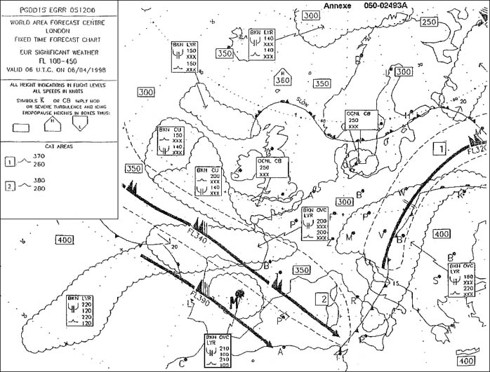
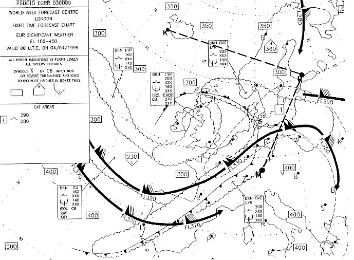
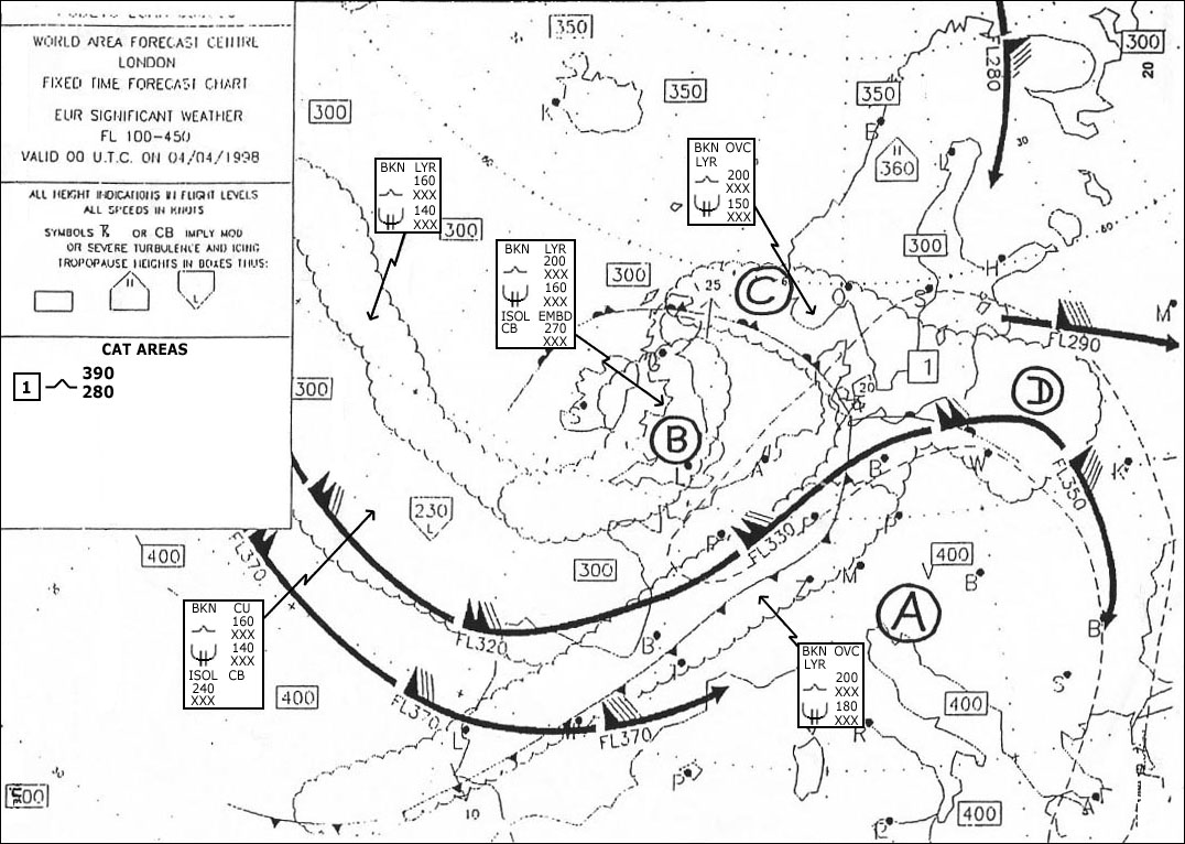
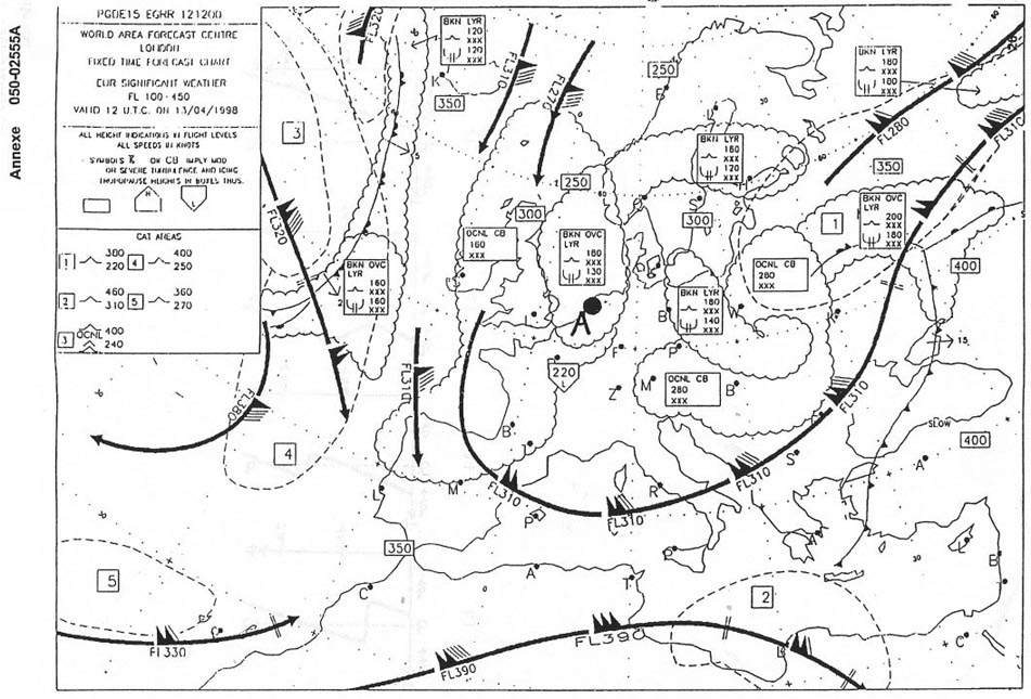
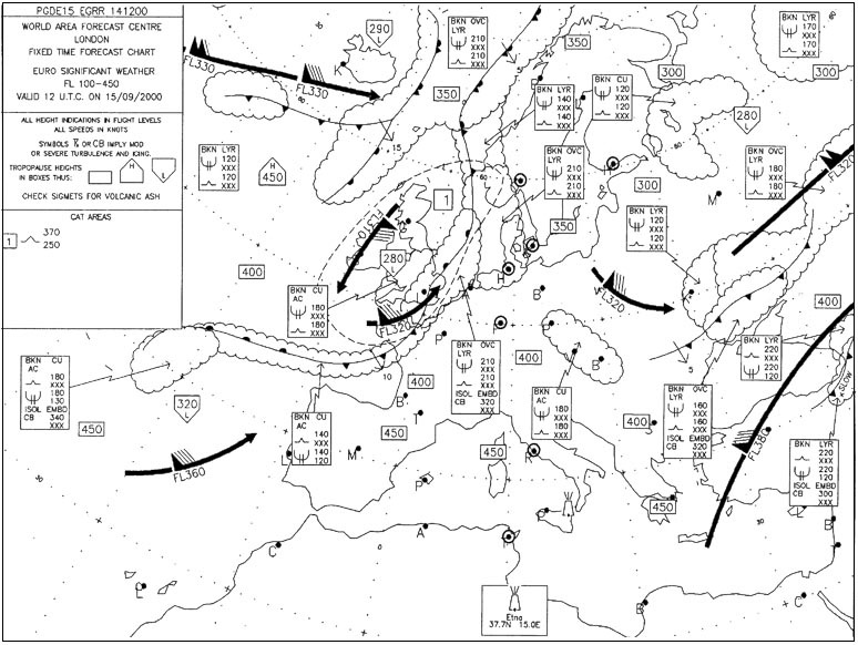
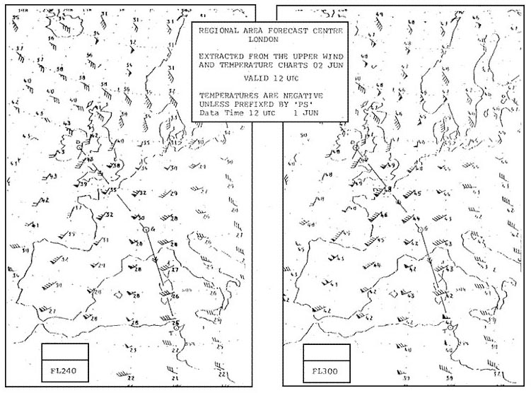
    If you are flying from zurich to stockholm at fl 240 what conditions can you expect at cruising altitude 400 Out of cloud throughout flight. the questions states at cruising altitude (fl240) only at this level you are out of cat area out of clud (top of clouds at fl150) there no scattered thunderstorms.

  • Question 135-28

    In which cloud type does moderate to severe airframe icing most probably occur In nimbostratus clouds. airframe icing will not happen in cirrus cloud (composed of ice crystals) or if temperature above 0ºc ns (nimbostratus) produces heavy rain if rain falls through a cold air mass (below freezing level) moderate to severe airframe icing can occur in clear air you can only have light icing.

  • Question 135-29

    Which of following clouds represents most stable air mass Altocumulus lenticularis. airframe icing will not happen in cirrus cloud (composed of ice crystals) or if temperature above 0ºc ns (nimbostratus) produces heavy rain if rain falls through a cold air mass (below freezing level) moderate to severe airframe icing can occur in clear air you can only have light icing.

  • Question 135-30

    A frontal depression passes through airport what form of precipitation do you expect Continuous rain or snow during 6 hours until warm front arrives the precipitation stops several hours within warm sector on arrival of cold front showers within a couple of hours. airframe icing will not happen in cirrus cloud (composed of ice crystals) or if temperature above 0ºc ns (nimbostratus) produces heavy rain if rain falls through a cold air mass (below freezing level) moderate to severe airframe icing can occur in clear air you can only have light icing.

  • Question 135-31

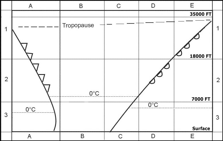
    Which of following are favourable conditions the formation of freezing rain Warm air aloft from which rain falling into air with a temperature below °c. freezing rain associated with warm fronts warm occlusions in a warm front freezing level lower than behind (in warm sector) the slope means that freezing rain will be falling on anything underneath so if you are flying towards a warm front (or warm occlusion) watch out! supercooled water droplets from above will freeze onto your cold airframe once you see ice pellets expect freezing rain next .

  • Question 135-32

    Which form of precipitation from clouds containing only water most likely to fall in mid latitudes Warm air aloft from which rain falling into air with a temperature below °c. large waterdropplets will only form in clouds with large vertical extent most likely also contain ice since this cloud only contains water it probably a normal stratus cloud the most likely answere therefore must be drizzle answers rain with large drops refer to cumulonimbus cloud at mid latitudes in summer a cumulonimbus cloud contains ice crystals water droplets supercooled water droplets.

  • Question 135-33

    Which of following zones most likely to encounter little or no precipitation The north side of alps with a prevailing foehn from south. foehn winds produce precipitation on windward side but are dry warm on lee ward side the lee ward side most likely zone to encounter little or no precipitation fronts occlusions produce plenty of precipitation.

  • Question 135-34

    What encountered during summer over land in centre of a cold air pool Showers thunderstorms. a cold pool a meteorologic term a cold air block it an area with light or no wind low temperature it a place of instability convective activity.

  • Question 135-35

    What type of cloud can produce hail showers Showers thunderstorms. a cold pool a meteorologic term a cold air block it an area with light or no wind low temperature it a place of instability convective activity.

  • Question 135-36

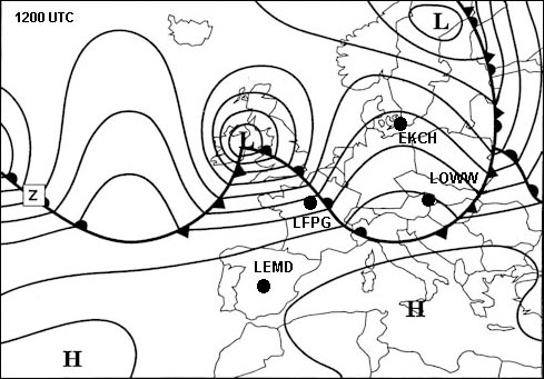
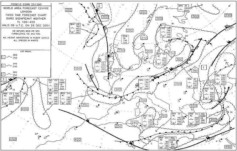
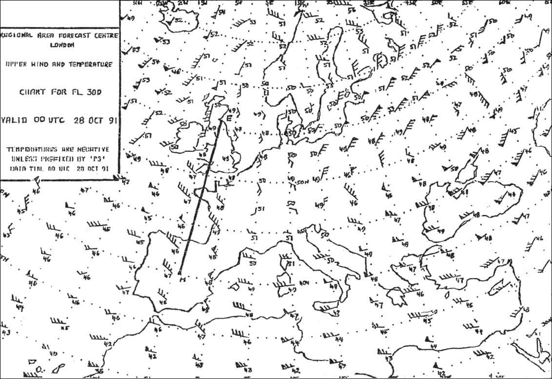
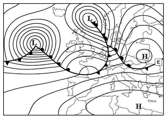
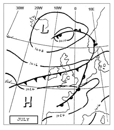
    Which airport at 1200 utc has lowest probability of precipitation 268 Showers thunderstorms. a cold pool a meteorologic term a cold air block it an area with light or no wind low temperature it a place of instability convective activity.

  • Question 135-37

    Flight lisbon to bordeaux eta 1800 utc what type of precipitation forecast on approach to bordeaux taf lfbd 281400z 281524 26015kt 9999 shra bkn020 tempo 1620 26020g30kt 8000 +shra bkn015cb prob30 tsra = Showers thunderstorms. a cold pool a meteorologic term a cold air block it an area with light or no wind low temperature it a place of instability convective activity.

  • Question 135-38

    An airborne weather radar installation makes it possible to detect location of Zones of precipitation particularly liquid state precipitation also their intensity. a cold pool a meteorologic term a cold air block it an area with light or no wind low temperature it a place of instability convective activity.

  • Question 135-39

    At which altitude at temperate latitudes may hail be expected in connection with a cb From ground up to a maximum of fl 45. a cold pool a meteorologic term a cold air block it an area with light or no wind low temperature it a place of instability convective activity.

  • Question 135-40

    With which of following types of cloud '+ra' precipitation most commonly associated From ground up to a maximum of fl 45. a cold pool a meteorologic term a cold air block it an area with light or no wind low temperature it a place of instability convective activity.


Exclusive rights reserved. Reproduction prohibited under penalty of prosecution.

5359 Free Training Exam