During periods of undisturbed radiation weather overland the ? [ Revision flight ]
Question 131-1 : Surface wind speed tends to be highest during the mid afternoon surface wind speed tends to be highest at night angle between isobars and surface wind direction tends to be greatest in the mid afternoon wind tends to back from early morning until early afternoon
 Surface wind speed tends to be highest during the mid afternoon.
 From summer to winter the polar front jet stream over the north atlantic moves ?
Question 131-2 : Towards the south and the speed increases towards the north and the speed increases towards the south and the speed decreases towards the north and the speed decreases
 Towards the south and the speed increases.
 In relation to the polar front jet stream the greatest rate of wind shear is ?
Question 131-3 : Close to the core on the polar side well below the core on the tropical side of the core 5000 ft or more above the core
 Close to the core on the polar side.
 In summer in the northern hemisphere the maximum wind speeds associated with ?
Question 131-4 : Below the tropopause at about 200 hpa above the tropopause at about 100 hpa below the tropopause at about 300 hpa above the tropopause at about 250 hpa
Isotachs are lines joining equal ?
Question 131-5 : Wind speeds sea level pressures horizontal wind speed gradients wind speed lapse rates
 Wind speeds.
 Maximum wind speeds associated with subtropical jet streams are usually located ?
Question 131-6 : Tropical air below the tropopause tropical air above the tropopause polar air above the tropopause polar air below the tropopause
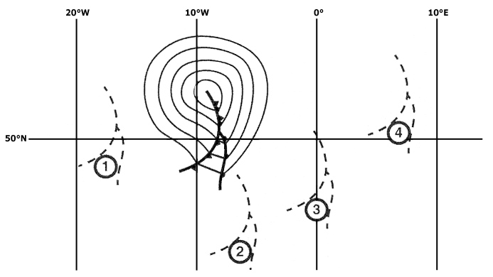 Tropical air below the tropopause.
 Sea breezes are most likely to occur when ?
Question 131-7 : Slack pressure gradient and clear skies result in relatively high land temperatures a strong pressure gradient relatively high sea temperatures and overcast conditions persist a strong pressure gradient relatively high sea temperatures and clear skies at night exist a slack pressure gradient relatively high sea temperatures and overcast conditions persist
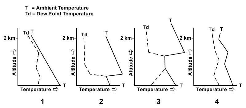 Slack pressure gradient and clear skies result in relatively high land temperatures.
 The length width and depth of a typical mid latitude jet stream are respectively ?
Question 131-8 : 1000 mn 150 mn 10000 ft 1000 mn 150 mn 30000 ft 1000 mn 5000 to 8000 ft 30000ft 200 mn 5 mn 10000 ft
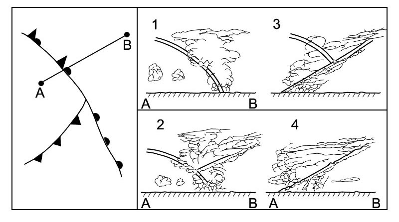 1000 mn, 150 mn, 10000 ft.
 The most likely place to encounter clear air turbulence associated with a jet ?
Question 131-9 : Close to the core on the side facing the polar air well below the core on the tropical side of the core 5000 feet or more above the core
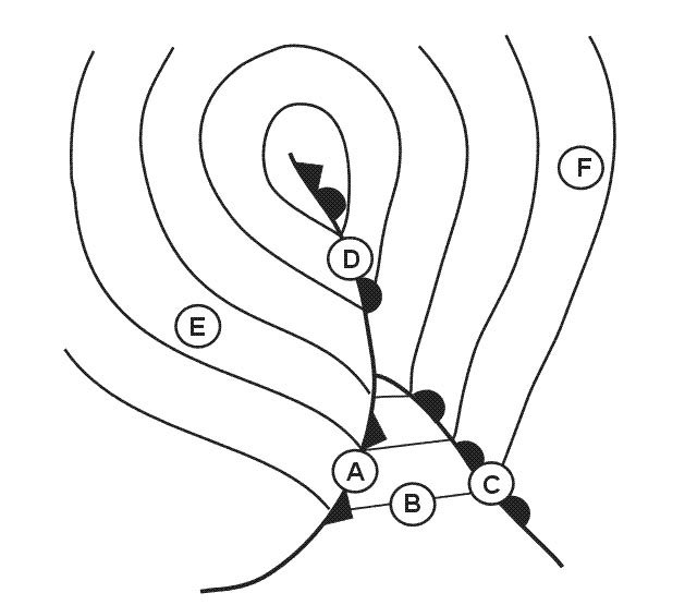 Close to the core on the side facing the polar air.
 What surface wind is forecast for 2200 utc .eddf 272200z 280624 vrb05kt 4000 br ?
Question 131-10 : 260°/10 kt variable/05 kt variable/15 to 25 kt calm
 260°/10 kt.
 What surface wind is forecast for eta 1700 utc at kingston .mkjp 160430z 160606 ?
Question 131-11 : 140° / 20 kt gusts 34 kt 360° / 10 kt 340° / 10 kt 140° / 27 kt
 140° / 20 kt gusts 34 kt.
 When and where is an easterly jet stream likely to be encountered ?
Question 131-12 : In summer from south east asia extending over southern india to central africa in winter along the russian coast facing the arctic ocean in summer from the middle east extending over the southern part of the mediterranean to southern spain throughout the year to the south of the azorian high
 In summer from south-east asia extending over southern india to central africa.
 When compared to the geostrophic wind in the northern hemisphere surface ?
Question 131-13 : Back and decrease back and increase veer and decrease veer and increase
 Back and decrease.
 Which area of a polar front jet stream in the northern hemisphere has the ?
Question 131-14 : Looking downstream the area to the left of the core looking downstream the area to the right of the core in the core of the jet stream above the core in the boundary between warm and cold air
 Looking downstream, the area to the left of the core.
 Which of the following statements concerning the variation in wind speed ?
Question 131-15 : Is greater in the winter remains the same all along the year almost about zero in winter is greater in the summer
 Is greater in the winter.
 Which of the following types of jet streams can be observed all year round ?
Question 131-16 : Subtropical jet stream and polar front jet stream equatorial jet stream and polar front jet stream arctic jet stream and subtropical jet stream equatorial jet stream and arctic jet stream
 Subtropical jet stream and polar front jet stream.
 Where as a general rule is the core of the polar front jet stream to be found ?
Question 131-17 : In the tropical air mass in the polar air mass just above the warm air tropopause just below the cold air tropopause
 In the tropical air mass.
 Where is the projection of the polar front jet stream on the surface most ?
Question 131-18 : 50 to 200 nm behind the cold front and 300 to 450 nm ahead of the warm front up to 100 nm either side of the cold front and up to 200 nm either side of the warm front up to 200 nm either side of the cold front and up to 200 nm either side of the warm front 300 to 450 nm behind the cold front and 50 to 200 nm ahead of the warm front
 50 to 200 nm behind the cold front and 300 to 450 nm ahead of the warm front.
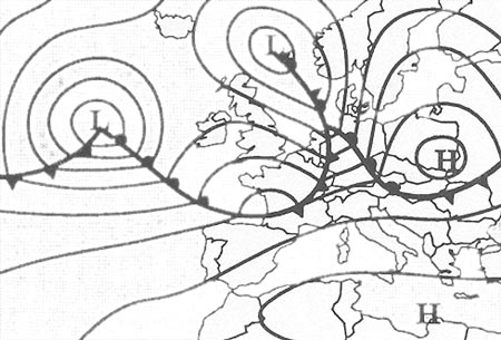
 Which statement is correct for the southern hemisphere ?
Question 131-19 : In the friction layer the wind backs with increasing height the jet streams are easterly the wind veers at the passage of a cold front if the wind veers with increasing height then warm air is advected
 In the friction layer the wind backs with increasing height.
 What is the best approximation for the wind speed at flight level 250 ?
Question 131-20 : By interpolation of the wind information available from the 500 and 300 hpa charts while also considering the maximum wind information found on the significant weather chart by simple interpolation of wind information available from the 500 and 300 hpa charts by reading wind direction and speed from the 300 hpa chart by reading wind direction and speed from the 500 hpa chart
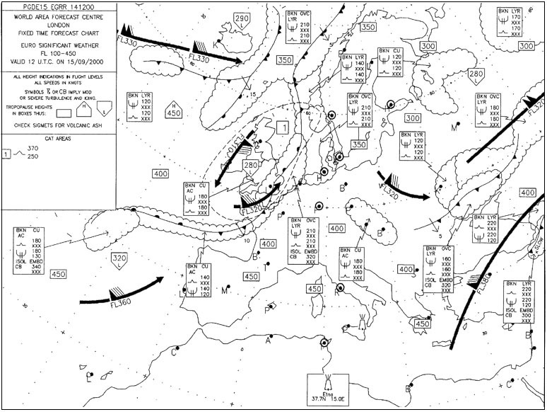 By interpolation of the wind information available from the 500 and 300 hpa charts, while also considering the maximum wind information found on the significant weather chart.
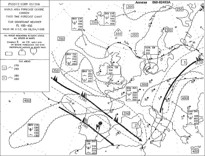
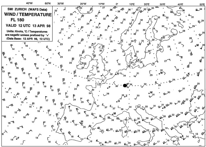
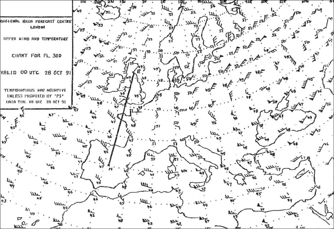
 What is the average wind forecast for fl 300 between edinburgh and madrid . 340 ?
Question 131-21 : 280°/30kt 300°/45kt 240°/25kt 180°/20kt
 280°/30kt.
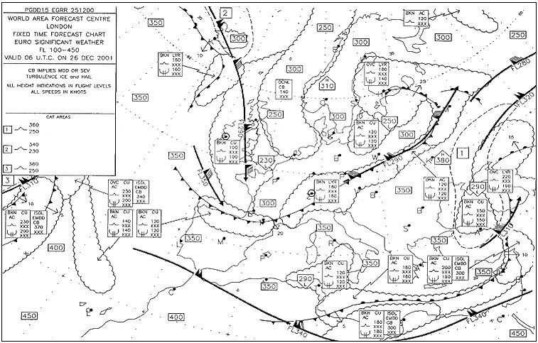
 At 40°n 20°w the forecast wind at fl 390 is . 345 ?
Question 131-22 : 090°/45 kt 060°/45 kt 070°/30 kt 270°/45 kt
 090°/45 kt.
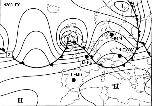
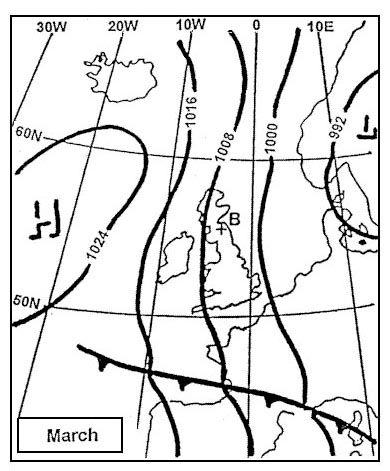
 What characteristics will the surface winds have in an area where the isobars ?
Question 131-23 : Strong and flowing somewhat across the isobars very weak but gusty and flowing somewhat across the isobars strong and flowing parallel to the isobars moderate and flowing parallel to the isobars
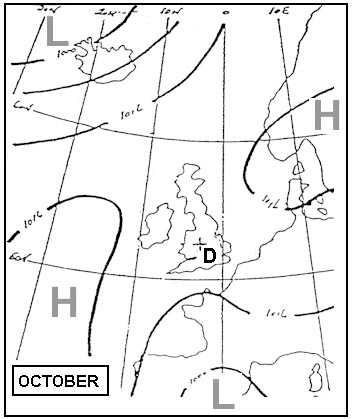 Strong and flowing somewhat across the isobars.
 What is necessary for the development of a polar front jet stream ?
Question 131-24 : Strong horizontal temperature gradients strong vertical temperature gradients a uniform pressure pattern an unstable atmosphere up to great heights
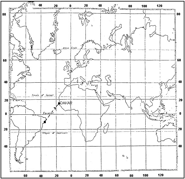 Strong horizontal temperature gradients.
 The average forecast wind for the leg from madrid to dhahran at fl 390 is . 361 ?
Question 131-25 : 270/50 270/30 320/70 310/50
 270/50.
 In the mid latitudes of the northern hemisphere the wind blows ?
Question 131-26 : Clockwise around anticyclones and anti clockwise around cyclones clockwise around anticyclones and cyclones clockwise around cyclones and anti clockwise around anticyclones direct from high to low pressure areas
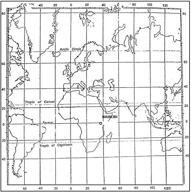 Clockwise around anticyclones and anti-clockwise around cyclones.
 In the northern hemisphere with an anticyclonic pressure system the geostrophic ?
Question 131-27 : 050°/10 kt 060°/10 kt 060°/20 kt 070°/20 kt
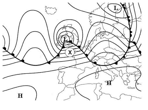 050°/10 kt.
 At which height and at what time of the year can an aircraft be affected by the ?
Question 131-28 : Fl 500 from june to august fl 500 from november to february fl 400 during the winter in the northern hemisphere fl 400 during the winter in the southern hemisphere
 Fl 500 from june to august.
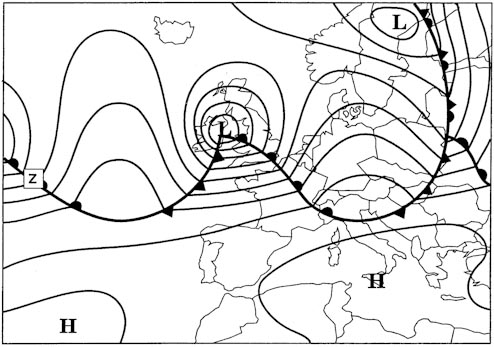
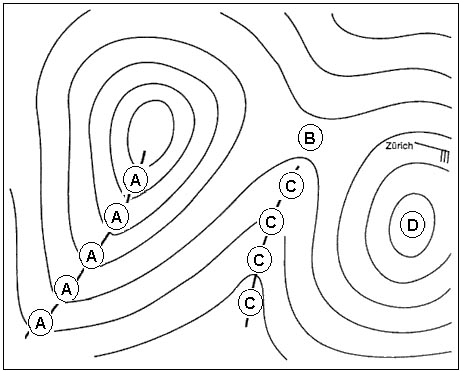
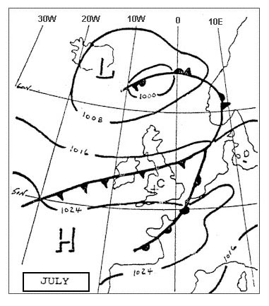
 According to the extract of the surface isobar map the surface wind direction ?
Question 131-29 : 140° 310° 220° 110°
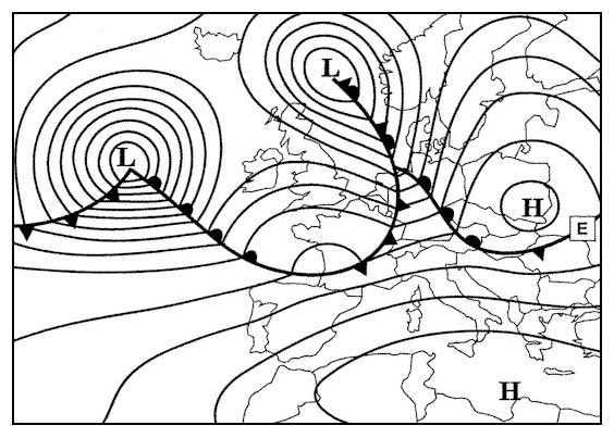 140°.
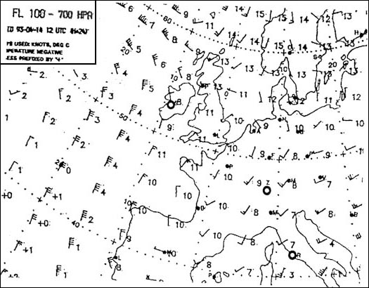
140°. In appendix are shown four sections of the 700 hpa wind chart the diagram ?
Question 131-30 : 030°/30 kt diagram a 210°/30 kt diagram b 030°/30 kt diagram c 210°/30 kt diagram d
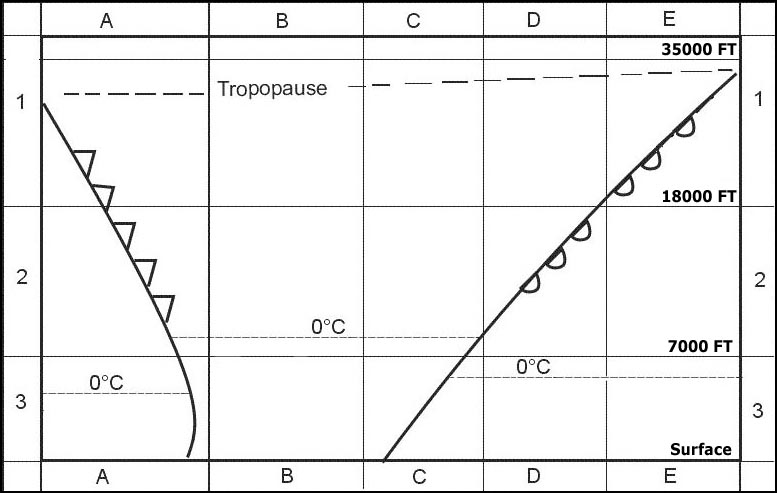 030°/30 kt (diagram a).
 At fl 300 between geneva and tunis what mean wind would be most likely . 367 ?
Question 131-31 : 245°/50 kt 225°/25 kt 265°/40 kt 265°/25 kt
 245°/50 kt.
 The mean wind that may be expected to affect the route segment from the coast ?
Question 131-32 : 220/70kt 245/55kt 240/90kt 270/70kt
 220/70kt.
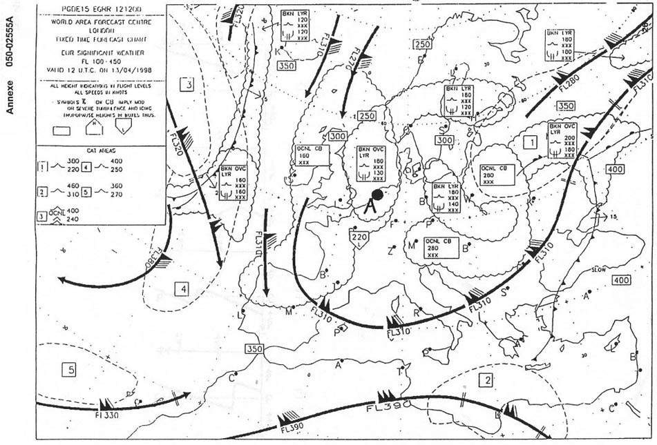
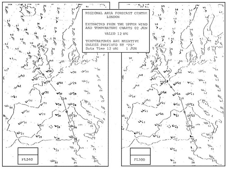
 Judging by the chart what wind speeds can you expect at fl 310 above london . ?
Question 131-33 : 90 kt 300 kt 140 kt 110 km/h
 90 kt.
 When in the northern hemisphere at the same latitude the distance between ?
Question 131-34 : The gradient wind in a low pressure area is weaker than in a high pressure area the geostrophic wind speed is less than the gradient wind speed in a low pressure area the coriolis force in a high pressure area is smaller than the gradient force in a high pressure area the wind around a low pressure area is stronger than around a high pressure area
 The gradient wind in a low pressure area is weaker than in a high pressure area.
 Which of the following statements is correct concerning the geostrophic wind ?
Question 131-35 : It is present at latitudes higher than about 15 degrees north/south it is present in a pressure system consisting of curved and non parallel isobars a horizontal temperature difference of at least 5 degrees celsius per 100 km is required to have geostrophic wind conditions it is only present in the friction layer
 It is present at latitudes higher than about 15 degrees north/south.
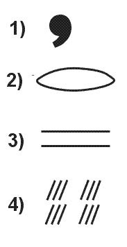
 What is the significance to aviation of breaks or steps in the tropopause ?
Question 131-36 : They indicate the position of strong upper winds they indicate the position and movement of anticyclones they indicate the position and movement of tropical revolving storms they indicate light winds at the surface the 'horse latitudes'
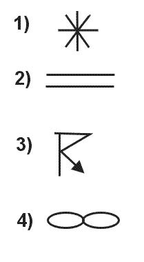 They indicate the position of strong upper winds.
 Where are the westerlies to be expected ?
Question 131-37 : In the mid latitudes in the subtropical high pressure belt between 10° and 30° north or south between 65° and 80° north or south
 In the mid-latitudes.
 Katabatic wind is ?
Question 131-38 : A flow of cold air down the slope of a mountain a flow of cold air blowing from sea to land a flow of warm air up the slope of a hill caused by surface heating a flow of warm air blowing from land to sea
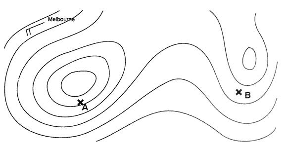 A flow of cold air down the slope of a mountain.
 What is the average wind forecast for fl 300 between moscow and kiev . 378 ?
Question 131-39 : 260/65 230/55 090/60 050/60
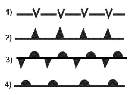 260/65.
 Which of the following is correct regarding geostrophic wind ?
Question 131-40 : It blows parallel to straight equidistant isobars it blows parallel to curved isobars it blows across the isobars from high to low pressure it is the wind resulting from the vector sum of gradient wind and surface wind such that the geostrophic wind normally blows at an angle of 20 45 degrees relative to the isobars
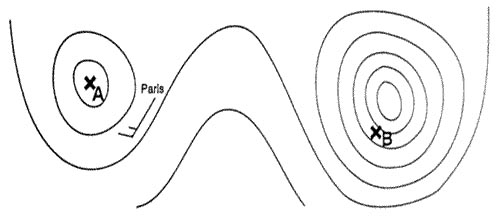 It blows parallel to straight equidistant isobars.
 ~
Exclusive rights reserved. Reproduction prohibited under penalty of prosecution.
5199 Free Training Exam
