Un compte Premium offert sur le site FCL.055 ! Rendez-vous sur www.fcl055-exam.fr puis créez un compte avec le même email que celui...   [Lire la suite]


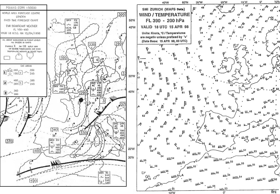
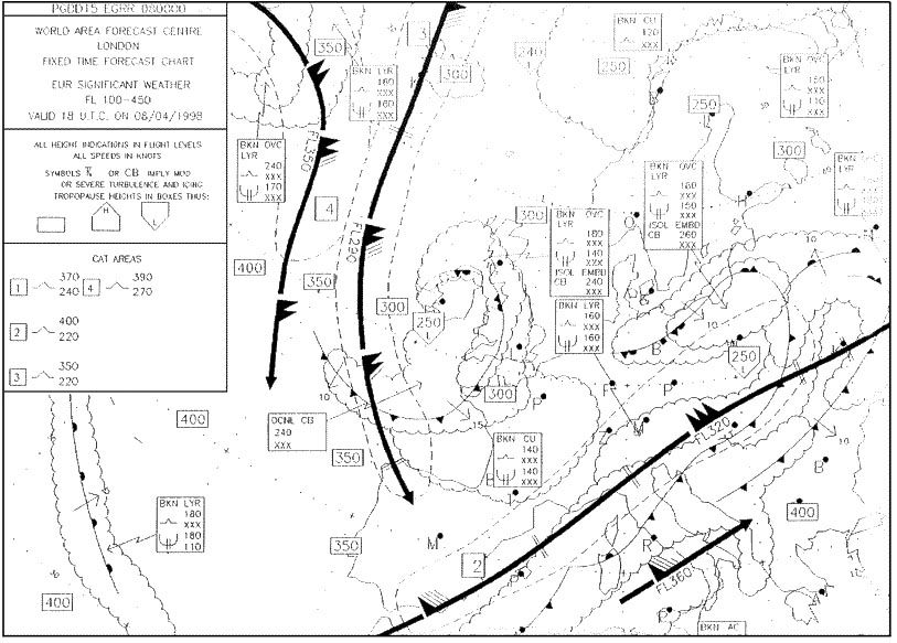
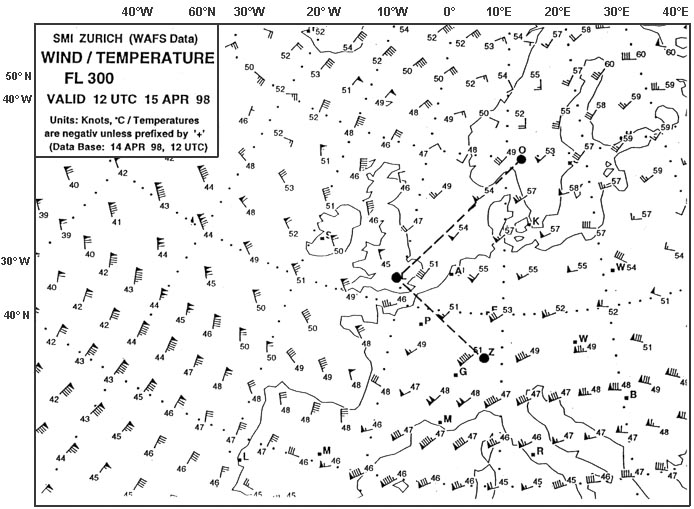
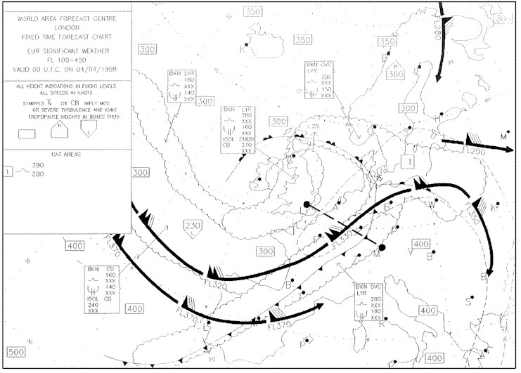
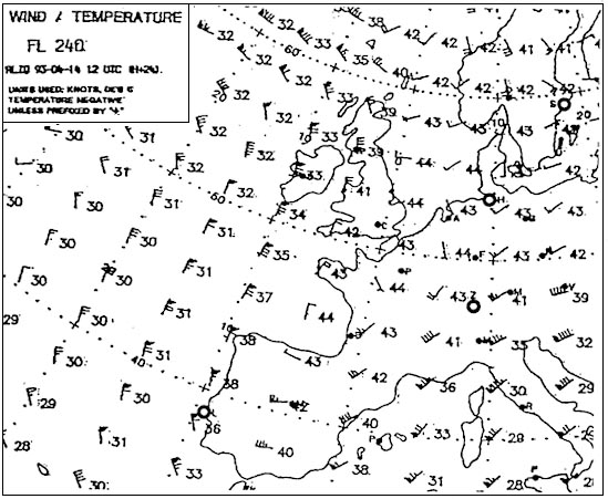
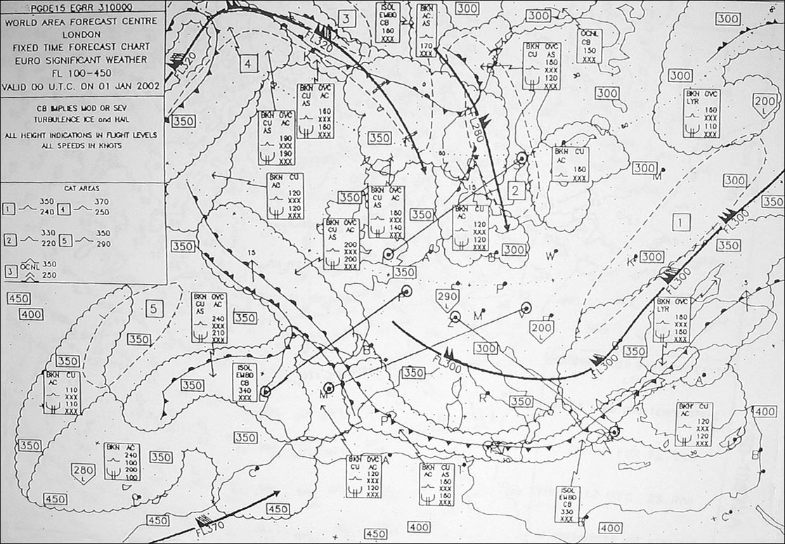
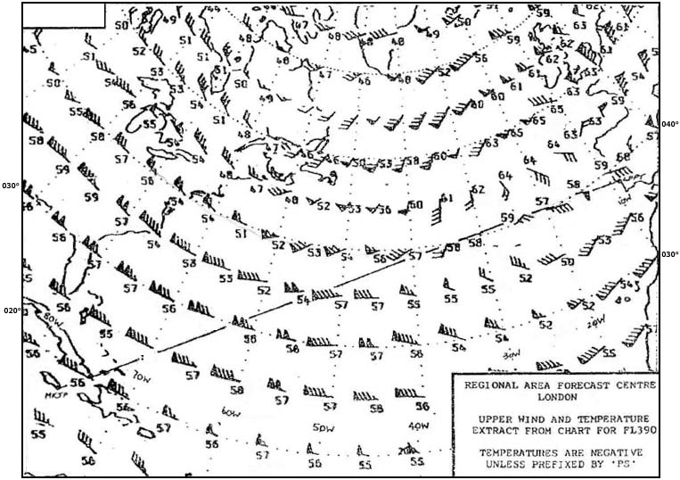
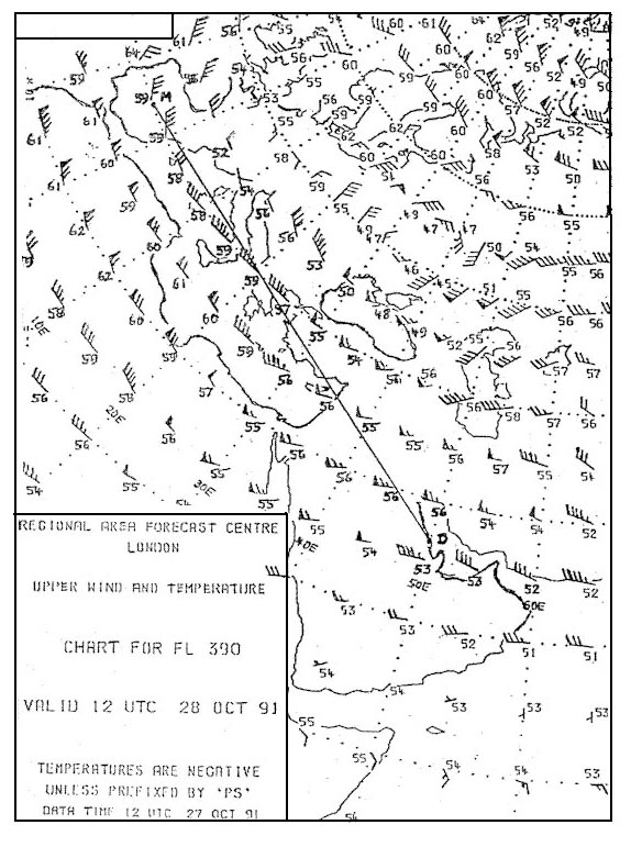
The mean wind that may be expected to affect the route segment from the coast of SE England to Geneva at FL 270 is 367 ?

Preparation > civilian

exemple reponse 240
be careful ! we are looking at wind only the part from coast of se england to geneva not from dublin to tunis over manche at fl240 wind is 200°/55 kt before geneva at fl240 wind is 220°/55 kt over manche at fl300 wind is 230°/80 kt before geneva at fl300 wind is 240°/80 kt whitout calculation answer 220/70 seems to be mean wind at fl270.


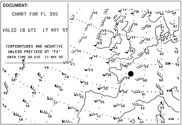
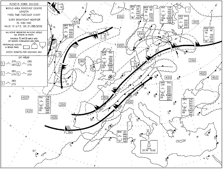
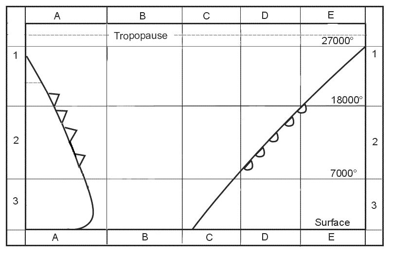
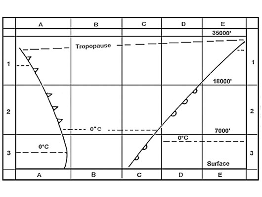
Judging by the chart what wind speeds can you expect at FL 310 above London 372 ?

exemple reponse 244
Judging the chart what wind speeds can you expect at fl 310 above london 372 a jet stream passing right above london at fl310 pennants correspond to 50 kt feathers correspond to 10 kt half feathers correspond to 5 kt 1 pennant + 4 feathers = 90 kt.

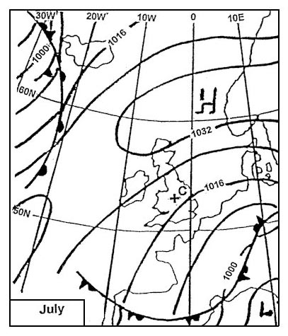
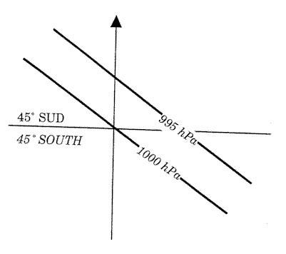
When in the northern hemisphere at the same latitude the distance between isobars is equal then ?

exemple reponse 245
When in northern hemisphere at same latitude distance between isobars equal then The gradient wind in a low pressure area weaker than in a high pressure area. Pressure gradient the difference in pressure between high low pressure areas wind speed directly proportional to pressure gradient this means strongest winds are in areas where pressure gradient the greatest the stronger pressure gradient (the more tightly packed isobars are) stronger wind speed.

  • exemple reponse 246
    Which of following statements correct concerning geostrophic wind It present at latitudes higher than about 5 degrees north/south. to have a geostrophic wind we need to have a pressure gradient force coriolis force (create earth's rotation depending on geographic latitude) we need to have two differents air mass to have a pressure gradient force (pgf) since earth rotates objects that are above earth apparently move or are deflected if they are already moving owing to it's rotation this apparent motion caused the coriolis force in northern hemisphere objects will be deflected to their right while in southern hemisphere objects will be deflected to their left the magnitude of deflection also a function of distance from equator velocity so farther from equator object is greater deflection the faster an object moving greater deflection these 'object can be anything from airplanes to birds to missiles to parcels of air the effect of coriolis force various latitudes we can see that coriolis force maximum at high latitudes minimum at equator thus geostrophic wind present at latitudes higher than about 15° north/south.

  • exemple reponse 247
    What the significance to aviation of breaks or steps in tropopause They indicate position of strong upper winds. The 'break or 'step in tropopause are at polar front at boundary between tropical sub tropical air which where polar front sub tropical jet streams are located this the position of strong upper winds.

  • exemple reponse 248
    Where are westerlies to be expected They indicate position of strong upper winds. westerlies average latitude are 50°n 50°s.

  • exemple reponse 250
    Katabatic wind A flow of cold air down slope of a mountain. Cqb15 september 2011.

  • Question 129-8

    What the average wind forecast fl 300 between moscow and kiev 378 A flow of cold air down slope of a mountain. close to moscow wind from 270°/65 kt close to kiev wind from 250°/80 kt.

  • Question 129-9

    Which of following correct regarding geostrophic wind It blows parallel to straight equidistant isobars. The speed of a geostrophic wind calculated from pressure gradient air density rotational velocity of earth latitude the calculation ignores curvature of wins path a geostrophic wind proportional to pressure gradient or inversely proportional to distance between isobars winds exist because of horizontal vertical pressure gradient so atmospheric motion can be deduced from isobaric surface charts etc if horizontal pressure gradient force exactly balanced in magnitude coriolis effect accelerations of air will be relatively small a geostrophic wind will flow horizontally at a constant speed proportional to isobaric spacing gradient perpendicular to two opposing forces parallel to straight isobars thus geostrophic wind speed proportional to pressure gradient the closer isobars higher will be geostrophic wind speed.

  • Question 129-10

    In this question wind speed with straight isobars vst wind speed around a high pressure system vhigh and wind speed around a low pressure system vlow in southern hemisphere are being compared while pressure gradient and latitude constant which statement correct Vst < vhigh vst > vlow. for same pressure gradient same latitude gradient wind 'high round a high' (vhigh) 'low round a low' (vlow) when compared to geostrophic wind (vst).

  • Question 129-11

    Which of following correct regarding wind speed in a jet stream in northern hemisphere With colder air to left when looking downwind wind speed increases with height while with colder air to right wind speed decreases with height. The jet lies in warm air above frontal surface looking downwind warm air tropopause lies to right above core cold air tropopause to left a litle lower than core looking downwind air in a jet core slowly rotates in a counterclockwise fashion if you stand with your back to wind have cold air on your left you are below core of jet wind speed will increase as you climb if you stand with your back to wind colder air (the colder air from warm tropopause which colder than air of cold tropopause) on your right you are above core of jet wind speed will decrease as you climb.

  • Question 129-12

    Strongest clear air turbulence to be expected On cold air side of jet stream core. This question similar to question 266 in which zone of a polar front jet stream the strongest cat to be expected ? on polar air side of core the strongest cat in warm tropical air but on cold polar air side of core.

  • Question 129-13

    Which of following statements correct regarding variation of wind with height The wind normally veers during climb out through first 2 3 feet in northern hemisphere. This question similar to question 266 in which zone of a polar front jet stream the strongest cat to be expected ? on polar air side of core the strongest cat in warm tropical air but on cold polar air side of core.

  • Question 129-14

    On which latitudes can coriolis force in practice be neglected meteorological purposes From to about degrees north south. This question similar to question 266 in which zone of a polar front jet stream the strongest cat to be expected ? on polar air side of core the strongest cat in warm tropical air but on cold polar air side of core.

  • Question 129-15

    Where the wind speed of a polar front jet stream normally at its strongest In area between a trough a ridge. Generally a trough (of low pressure) refers to region of low pressure within v shaped isobars it usually projects from a large distant depression there a sudden wind shift across axis (the axis shown as broken lines on a weather chart) of trough which associated with cloud rain a ridge (of high pressure) refers to a wedge shaped extension of a high pressure area occurs between two depressions or lows wind shift gradual across a ridge shown as zig zag line the ridge has a central area of light winds clear skies the ridge trough are usually associated with different air masses warm cold this where you get maximum temperature contrast strongest thermal wind speed.

  • Question 129-16

    What the icao qualifying term the described intensity of turbulence 'conditions in which abrupt changes in aircraft attitude and/or altitude occur aircraft may be out of control short period In area between a trough a ridge. Ecqb01 2013 procedures air navigation services air traffic management (pans atm doc 4444) instructions for air reporting by voice communications moderate conditions in which moderate changes in aircraft attitude and/or altitude may occur but aircraft remains in positive control at all times usually small variations in airspeed changes in accelerometer readings of 0 5 g to 1 0 g at aircraft's centre of gravity difficulty in walking occupants feel strain against seat belts loose objects move about severe conditions in which abrupt changes in aircraft attitude and/or altitude occur aircraft may be out of control short periods usually large variations in airspeed changes in accelerometer readings greater than 1 0 g at aircraft's centre of gravity occupants are forced violently against seat belts loose objects are tossed about.

  • Question 129-17

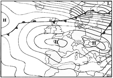
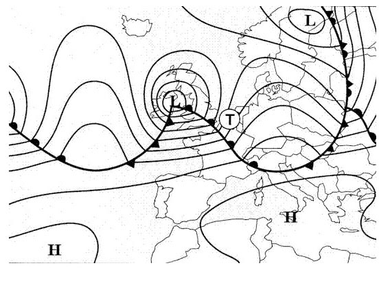
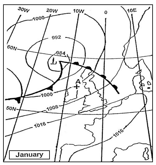
    What wind direction will occur over land at point e 388 In area between a trough a ridge. at low elevations friction will slow air hence coriolis force will be less effective in its deflection of wind as elevation decreases direction backs (changes direction in an counter clockwise motion) in northern hemisphere at mid latitude over land wind speed in friction layer decrease 50% angle between wind direction isobars changes 30° (value to be used in examinations) we are in northern hemisphere (from way fronts are positioned) therefore at point e wind from west.

  • Question 129-18

    What wind direction will occur over land at point b 389 In area between a trough a ridge. at low elevations friction will slow air hence coriolis force will be less effective in its deflection of wind as elevation decreases direction backs (changes direction in an counter clockwise motion) in northern hemisphere at mid latitude over land wind speed in friction layer decrease 50% angle between wind direction isobars changes 30° (value to be used in examinations) we are in northern hemisphere (from way fronts are positioned) therefore at point b wind from southwest.

  • Question 129-19

    What kind of turbulence caused the friction of air flowing over earth's surface Mechanical turbulence. at low elevations friction will slow air hence coriolis force will be less effective in its deflection of wind as elevation decreases direction backs (changes direction in an counter clockwise motion) in northern hemisphere at mid latitude over land wind speed in friction layer decrease 50% angle between wind direction isobars changes 30° (value to be used in examinations) we are in northern hemisphere (from way fronts are positioned) therefore at point b wind from southwest.

  • Question 129-20

    Which of following values corresponds to a ne wind Mechanical turbulence. at low elevations friction will slow air hence coriolis force will be less effective in its deflection of wind as elevation decreases direction backs (changes direction in an counter clockwise motion) in northern hemisphere at mid latitude over land wind speed in friction layer decrease 50% angle between wind direction isobars changes 30° (value to be used in examinations) we are in northern hemisphere (from way fronts are positioned) therefore at point b wind from southwest.

  • Question 129-21

    Which of following values corresponds to a se wind Mechanical turbulence. at low elevations friction will slow air hence coriolis force will be less effective in its deflection of wind as elevation decreases direction backs (changes direction in an counter clockwise motion) in northern hemisphere at mid latitude over land wind speed in friction layer decrease 50% angle between wind direction isobars changes 30° (value to be used in examinations) we are in northern hemisphere (from way fronts are positioned) therefore at point b wind from southwest.

  • Question 129-22

    Which of following values corresponds to a nw wind Mechanical turbulence. at low elevations friction will slow air hence coriolis force will be less effective in its deflection of wind as elevation decreases direction backs (changes direction in an counter clockwise motion) in northern hemisphere at mid latitude over land wind speed in friction layer decrease 50% angle between wind direction isobars changes 30° (value to be used in examinations) we are in northern hemisphere (from way fronts are positioned) therefore at point b wind from southwest.

  • Question 129-23

    Which of following values corresponds to a sw wind Mechanical turbulence. at low elevations friction will slow air hence coriolis force will be less effective in its deflection of wind as elevation decreases direction backs (changes direction in an counter clockwise motion) in northern hemisphere at mid latitude over land wind speed in friction layer decrease 50% angle between wind direction isobars changes 30° (value to be used in examinations) we are in northern hemisphere (from way fronts are positioned) therefore at point b wind from southwest.

  • Question 129-24

    What the average wind at fl 160 between zurich and rome 397 Mechanical turbulence. at low elevations friction will slow air hence coriolis force will be less effective in its deflection of wind as elevation decreases direction backs (changes direction in an counter clockwise motion) in northern hemisphere at mid latitude over land wind speed in friction layer decrease 50% angle between wind direction isobars changes 30° (value to be used in examinations) we are in northern hemisphere (from way fronts are positioned) therefore at point b wind from southwest.

  • Question 129-25

    Judging the chart what windspeeds can you expect at fl 340 above rome 398 Mechanical turbulence. at low elevations friction will slow air hence coriolis force will be less effective in its deflection of wind as elevation decreases direction backs (changes direction in an counter clockwise motion) in northern hemisphere at mid latitude over land wind speed in friction layer decrease 50% angle between wind direction isobars changes 30° (value to be used in examinations) we are in northern hemisphere (from way fronts are positioned) therefore at point b wind from southwest.

  • Question 129-26

    Select from map average wind the route frankfurt rome at fl 170 408 Mechanical turbulence. at fl180 you will find an average wind from 235° a speed of (15 + 15 + 35 + 50 + 70) / 5 = 37 kt closest answer 230°/40 kt.

  • Question 129-27

    At 40°n 70°w forecast wind 416 Mechanical turbulence. at fl180 you will find an average wind from 235° a speed of (15 + 15 + 35 + 50 + 70) / 5 = 37 kt closest answer 230°/40 kt.

  • Question 129-28

    A layer conditionally unstable if air Is unstable saturated air stable dry air. if environmental lapse rate (elr) more than 3°c/1000 ft (dry adiabatic lapse rate) environment unstable if environmental lapse rate (elr) less than 1 8°c/1000 ft (saturated adiabatic lapse rate) environment stable but if environmental lapse rate (elr) more than 1 8°c/1000 ft but less than 3°c/1000 ft we have conditional stability stable if air dry (unsaturated) or unstable if air saturated.

  • Question 129-29

    A parcel of unsaturated air lifted to just below condensation level and then returned to its original level what the final temperature of parcel of air The same as starting temperature. air can hold a certain amount of water depending on it's temperature warmer air can hold more water vapour than colder air will climbing parcel cools hold less water vapour when parcel comes back at its original level it will warm come back in his original state.

  • Question 129-30

    What characteristic associated with a temperature inversion The same as starting temperature. air can hold a certain amount of water depending on it's temperature warmer air can hold more water vapour than colder air will climbing parcel cools hold less water vapour when parcel comes back at its original level it will warm come back in his original state.

  • Question 129-31

    Absolute instability said to exist whenever environmental lapse rate Exceeds dry adiabatic lapse rate. if environmental lapse rate (elr) more than 3°c/1000 ft (dry adiabatic lapse rate) environment unstable if environmental lapse rate (elr) less than 1 8°c/1000 ft (saturated adiabatic lapse rate) environment stable but if environmental lapse rate (elr) more than 1 8°c/1000 ft but less than 3°c/1000 ft we have conditional stability stable if air dry (unsaturated) or unstable if air saturated.

  • Question 129-32

    Which of following a possible consequence of subsidence An inversion over a large area with haze mist. sinking air will dissipate cloud especially at lower levels trap any pollution giving poor visibility.

  • Question 129-33

    What does 'dew point' mean The temperature to which a mass of air must be cooled in order to reach saturation. sinking air will dissipate cloud especially at lower levels trap any pollution giving poor visibility.

  • Question 129-34

    Which of following the definition of relative humidity Ratio between actual mixing ratio the saturation mixing ratio x . the most commonly used measure of humidity relative humidity relative humidity can be simply defined as amount of water in air relative to saturation amount air can hold at a given temperature multiplied 100 air with a relative humidity of 50% contains a half of water vapor it could hold at a particular temperature concept of relative humidity.

  • Question 129-35

    The relative humidity of a sample air mass 50% how the relative humidity of this air mass influenced changes of amount of water vapour in it It increases with increasing water vapour. the most commonly used measure of humidity relative humidity relative humidity can be simply defined as amount of water in air relative to saturation amount air can hold at a given temperature multiplied 100 air with a relative humidity of 50% contains a half of water vapor it could hold at a particular temperature concept of relative humidity.

  • Question 129-36

    Relative humidity Changes when water vapour added even though temperature remains constant. the most commonly used measure of humidity relative humidity relative humidity can be simply defined as amount of water in air relative to saturation amount air can hold at a given temperature multiplied 100 air with a relative humidity of 50% contains a half of water vapor it could hold at a particular temperature concept of relative humidity.

  • Question 129-37

    How if at all the relative humidity of an unsaturated air mass influenced temperature changes It decreases with increasing temperature. the most commonly used measure of humidity relative humidity relative humidity can be simply defined as amount of water in air relative to saturation amount air can hold at a given temperature multiplied 100 air with a relative humidity of 50% contains a half of water vapor it could hold at a particular temperature concept of relative humidity.

  • Question 129-38

    How does relative humidity and dewpoint in an unsaturated air mass change with varying temperature When temperature increases relative humidity decreases the dewpoint remains constant. relative humidity a percentage based on how much moisture in air versus how much moisture air can hold relative humidity will change if moisture added to or taken from air mass or if temperature changes if temperature increases relative humidity decreases if temperature decreases relative humidity increases the dewpoint the temperature that atmosphere must reach a parcel of air to become fully saturated in an unsaturated air mass dewpoint will remains constant if temperature changes.

  • Question 129-39

    When a given mass of air descends what effect will it have on relative humidity When temperature increases relative humidity decreases the dewpoint remains constant. when air descends its temperature increases if temperature increases relative humidity will decrease .

  • Question 129-40

    During late afternoon an air temperature of +12°c and a dew point of +5°c were measured what temperature change must at least occur during night in order to induce saturation It must decrease to +5°c. if air temperature decreases 5°c air temperature will not be saturated (12°c 5°c = 7°c) so air temperature must decrease to +5°c to become saturated (air temperature dew point must be equal).


Exclusive rights reserved. Reproduction prohibited under penalty of prosecution.

5119 Free Training Exam