Which of the following correctly lists special purpose codes that are to be used in conjunction with Secondary Surveillance Radar SSR ?
Multiple > protocol
Other study patent: Telepilote theorique examen 7
When should the latest QNH altimeter setting for the aerodrome be obtained ?
When should the flight crew shall be provided with the transition level ?
The calculated height of transition altitude shall be rounded up to next full In due time prior to reaching it during descent. icao doc 8168 2 1 2 transition altitude 2 1 2 4 the height above aerodrome of transition altitude shall be as low as possible but normally not less than 900 m (3 000 ft) 2 1 2 5 the calculated height of transition altitude shall be rounded up to next full 300 m (1000 ft). 
Omnidirectional departure normally allow departure in any direction if any restriction exist restricted areas/sectors are described means of In due time prior to reaching it during descent. icao doc 8168 2 1 2 transition altitude 2 1 2 4 the height above aerodrome of transition altitude shall be as low as possible but normally not less than 900 m (3 000 ft) 2 1 2 5 the calculated height of transition altitude shall be rounded up to next full 300 m (1000 ft). 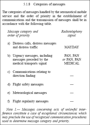
Unless otherwise published or instructed atc all turns after initial entry into holding pattern shall be made into which direction In due time prior to reaching it during descent. A standard holding pattern uses right hand turns takes approximately 4 minutes to complete (one minute each 180 degree turn two one minute straight ahead sections). 
Altimeter pressure settings provided to aircraft shall be rounded Down to next hectopascal. A standard holding pattern uses right hand turns takes approximately 4 minutes to complete (one minute each 180 degree turn two one minute straight ahead sections). Question 7-8
For construction of precision approaches which the operationally preferred glide path angle Down to next hectopascal. icao doc 8168 5 6 precision approach glide path angle/elevation angle for ils/mls/gls following minimum optimum maximum glide path angles/elevation angles are established minimum 2 5° optimum 3 0° maximum 3 5° (3° cat ii/iii operations). Question 7-9
In an instrument approach procedures what the name of segment connecting initial and final approach segments Intermediate segment. Doc 8168 chapter 4 intermediate approach segment this the segment during which aircraft speed configuration should be adjusted to prepare aircraft final approach for this reason descent gradient kept as shallow as possible during intermediate approach obstacle clearance requirement reduces from 300 m (984 ft) to 150 m (492 ft) in primary area reducing laterally to zero at outer edge of secondary area . Question 7-10
The fixes connecting arrival segment and final approach fix or point are Intermediate segment. Ecqb october 2017 ulc/caa poland iaf initial approach fix if intermediate fix faf/fap final approach fix or point mapt missed approach point. Question 7-11
When should flight crew shall be provided with transition level Before beginning initial approach to an aerodrome. Ecqb04 october 2017 icao doc8168 3 5 approach and landing 3 5 1 before beginning initial approach to an aerodrome number of transition level shall be obtained note the transition level normally obtained from appropriate air traffic services unit 3 5 2 before descending below transition level latest qnh altimeter setting the aerodrome shall be obtained note the latest qnh altimeter setting the aerodrome normally obtained from appropriate air traffic services unit 3 5 3 as aircraft descends through transition level reference the vertical position of aircraft shall be changed from flight levels (1 013 2 hpa) to altitudes (qnh) from this point on vertical position of aircraft shall be expressed in terms of altitudes. Question 7-12
Approach segments in an instrument approach procedures during intermediate segment The aircraft speed configuration should be adjusted to prepare aircraft final approach. Doc 8168 chapter 4 intermediate approach segment this the segment during which aircraft speed configuration should be adjusted to prepare aircraft final approach for this reason descent gradient kept as shallow as possible the final approach segment the segment in which alignment descent landing are made. Question 7-13
Approach segments in an instrument approach procedures during initial segment The aircraft leaves en route structure is manoeuvring to enter intermediate approach segment. Ecqb04 november 2017 doc 8168 chapter 4 the initial approach segment begins at initial approach fix (iaf) ends at intermediate fix (if) in initial approach aircraft has left en route structure is manoeuvring to enter intermediate approach segment intermediate approach segment this the segment during which aircraft speed configuration should be adjusted to prepare aircraft final approach for this reason descent gradient kept as shallow as possible the final approach segment the segment in which alignment descent landing are made. Question 7-14
A control zone shall extend laterally to at least 5 nm from centre of aerodrome or aerodromes concerned in direction from which approaches may be made. A control zone a controlled airspace extending upwards from surface of earth to a specified upper limit annex 11 air traffic services 2 10 5 control zones 2 10 5 1 the lateral limits of control zones shall encompass at least those portions of airspace which are not within control areas containing paths of ifr flights arriving at departing from aerodromes to be used under instrument meteorological conditions 2 10 5 2 the lateral limits of a control zone shall extend to at least 9 3 km (5 nm) from centre of aerodrome or aerodromes concerned in directions from which approaches may be made. Question 7-15
A controlled airspace extending upwards from a specified limit above earth 5 nm from centre of aerodrome or aerodromes concerned in direction from which approaches may be made. Pans atm doc4444 control zone (ctr) controlled airspace extending upwards from surface of earth to a specified upper limit controlled airspace an airspace of defined dimensions within which air traffic control service provided in accordance with airspace classification note controlled airspace a generic term which covers ats airspace classes a b c d e control area (cta) a controlled airspace extending upwards from a specified limit above earth advisory airspace an airspace of defined dimensions or designated route within which air traffic advisory service available. Question 7-16
A controlled airspace extending upwards from surface of earth to a specified upper limit 5 nm from centre of aerodrome or aerodromes concerned in direction from which approaches may be made. Pans atm doc4444 control zone (ctr) controlled airspace extending upwards from surface of earth to a specified upper limit controlled airspace an airspace of defined dimensions within which air traffic control service provided in accordance with airspace classification note controlled airspace a generic term which covers ats airspace classes a b c d e control area (cta) a controlled airspace extending upwards from a specified limit above earth advisory airspace an airspace of defined dimensions or designated route within which air traffic advisory service available. Question 7-17
Which the content of section 2 of air report airep Estimated time of arrival (eta) endurance. Pans atm doc4444 control zone (ctr) controlled airspace extending upwards from surface of earth to a specified upper limit controlled airspace an airspace of defined dimensions within which air traffic control service provided in accordance with airspace classification note controlled airspace a generic term which covers ats airspace classes a b c d e control area (cta) a controlled airspace extending upwards from a specified limit above earth advisory airspace an airspace of defined dimensions or designated route within which air traffic advisory service available. Question 7-18
A lower limit of a control area shall be established at a height above ground level or water of not less than Estimated time of arrival (eta) endurance. Pans atm doc4444 control area (cta) a controlled airspace extending upwards from a specified limit above earth it a volume of controlled airspace that exists in vicinity of an airport it has a specified lower level a specified upper level a cta a box of airspace that does not touch surface of earth annex 11 air traffic services specified a lower limit at a height above ground or water of not less than 200 m (700 ft). Question 7-19
A minimum vertical separation shall be provided until aircraft are established inbound on ils localizer course and/or mls final approach track this minimum when independent parallel approaches are being conducted Estimated time of arrival (eta) endurance. Doc pans atm 4444 6 7 3 2 4 a minimum of 300 m (1000 ft) vertical separation or subject to radar system situation display capabilities a minimum of 5 6 km (3 0 nm) radar separation shall be provided until aircraft are established a) inbound on ils localizer course and/or mls final approach track and b) within normal operating zone (noz). Question 7-20
A 'rnav' distance based separation minimum may be used at time level crossed provided that each aircraft reports its distance to or from same 'on track' way point this minimum Estimated time of arrival (eta) endurance. Doc 4444 5 4 2 6 longitudinal separation minima based on distance using rnav where rnp is specified 5 4 2 6 2 separation shall be established maintaining not less than specified distance between aircraft positions as reported reference to same 'on track' common point whenever possible ahead of both aircraft or means of an automated position reporting system figure 5 26a 150 km (80 nm) rnav based separation between aircraft climbing on same track. Question 7-21
A separation minimum shall be applied between a light or medium aircraft and a heavy aircraft and between a light aircraft and a medium aircraft when heavier aircraft making a low or missed approach and lighter aircraft landing on same runway in opposite direction or on a parallel opposite direction runway separated Estimated time of arrival (eta) endurance. Pans atm doc4444 a separation minimum of 2 minutes shall be applied between a light or medium aircraft a heavy aircraft between a light aircraft a medium aircraft when heavier aircraft making a low or missed approach the lighter aircraft is a) utilizing an opposite direction runway take off or b) landing on same runway in opposite direction or on a parallel opposite direction runway separated less than 760 m (2500 ft) . Question 7-22
A so called 'visual approach' can be performed During ifr flights if there permanent sight on movement area the underlying ground. doc 4444 icao pans atm definitions visual approach an approach an ifr flight when either part or all of an instrument approach procedure not completed the approach executed in visual reference to terrain 6 5 3 visual approach 6 5 3 1 clearance an ifr flight to execute a visual approach may be requested a flight crew or initiated the controller in latter case concurrence of flight crew shall be required 6 5 3 2 controllers shall exercise caution in initiating a visual approach when there reason to believe that flight crew concerned not familiar with aerodrome its surrounding terrain controllers should also take into consideration prevailing traffic meteorological conditions when initiating visual approaches 6 5 3 3 an ifr flight may be cleared to execute a visual approach provided pilot can maintain visual reference to terrain and a) reported ceiling at or above level of beginning of initial approach segment the aircraft so cleared or b) pilot reports at level of beginning of initial approach segment or at any time during instrument approach procedure that meteorological conditions are such that with reasonable assurance a visual approach landing can be completed. Question 7-23
A special air report comprises a number of sections in section i pilot fills in A position report including aircraft identification height position time. Pans atm doc4444 4 12 reporting of operational and meteorological information 4 12 1 general 4 12 1 1 when operational and/or routine meteorological information to be reported using data link an aircraft en route at times where position reports are required in accordance with 4 11 1 1 4 11 1 2 position report shall be given in accordance with 4 11 5 2 (requirements concerning transmission of meteorological information from ads c equipped aircraft) or in form of a routine air report special aircraft observations shall be reported as special air reports all air reports shall be reported as soon as practicable 4 12 3 3 when voice communications are used special air reports shall contain following elements message type designator section 1 position information 1) aircraft identification 2) position 3) time 4) flight level or altitude. Question 7-24
A strayed aircraft An aircraft which has deviated significantly from its intended track or which reports that it lost. Pans atm doc4444 4 12 reporting of operational and meteorological information 4 12 1 general 4 12 1 1 when operational and/or routine meteorological information to be reported using data link an aircraft en route at times where position reports are required in accordance with 4 11 1 1 4 11 1 2 position report shall be given in accordance with 4 11 5 2 (requirements concerning transmission of meteorological information from ads c equipped aircraft) or in form of a routine air report special aircraft observations shall be reported as special air reports all air reports shall be reported as soon as practicable 4 12 3 3 when voice communications are used special air reports shall contain following elements message type designator section 1 position information 1) aircraft identification 2) position 3) time 4) flight level or altitude. Question 7-25
A vfr flight when flying inside an ats airspace classified as b has to maintain following minima of flight visibility and distance from clouds 5 km below 3 5 m ( ft) ams 5 m horizontal 3 m vertical from clouds. sera 5001 vmc visibility distance from cloud minima * when height of transition altitude lower than 3050 m (10000 ft) amsl fl 100 shall be used in lieu of 10000 ft ** when so prescribed the appropriate ats authority a) flight visibilities reduced to not less than 1 500 m may be permitted flights operating (1) at speeds of 140 kts ias or less to give adequate opportunity to observe other traffic or any obstacles in time to avoid collision or (2) in circumstances in which probability of encounters with other traffic would normally be low e g in areas of low volume traffic for aerial work at low levels (b) helicopters may be permitted to operate in less than 1 500 m but not less than 800 m flight visibility if manoeuvred at a speed that will give adequate opportunity to observe other traffic or any obstacles in time to avoid collision flight visibilities lower than 800 m may be permitted special cases such as medical flights search rescue operations fire fighting *** the vmc minima in class a airspace are included guidance to pilots do not imply acceptance of vfr flights in class a airspace. Question 7-26
A vfr flight when flying inside an ats airspace classified as c has to maintain following minima of flight visibility and distance from clouds 8 km at or above 3 5 m ( ft) amsl 5 m horizontal 3 m vertical from clouds. sera 5001 vmc visibility distance from cloud minima * when height of transition altitude lower than 3050 m (10000 ft) amsl fl 100 shall be used in lieu of 10000 ft ** when so prescribed the appropriate ats authority a) flight visibilities reduced to not less than 1 500 m may be permitted flights operating (1) at speeds of 140 kts ias or less to give adequate opportunity to observe other traffic or any obstacles in time to avoid collision or (2) in circumstances in which probability of encounters with other traffic would normally be low e g in areas of low volume traffic for aerial work at low levels (b) helicopters may be permitted to operate in less than 1 500 m but not less than 800 m flight visibility if manoeuvred at a speed that will give adequate opportunity to observe other traffic or any obstacles in time to avoid collision flight visibilities lower than 800 m may be permitted special cases such as medical flights search rescue operations fire fighting *** the vmc minima in class a airspace are included guidance to pilots do not imply acceptance of vfr flights in class a airspace. Question 7-27
According to international agreements wind direction shall be adjusted to local variation and given in degrees magnetic Before landing take off. sera 5001 vmc visibility distance from cloud minima * when height of transition altitude lower than 3050 m (10000 ft) amsl fl 100 shall be used in lieu of 10000 ft ** when so prescribed the appropriate ats authority a) flight visibilities reduced to not less than 1 500 m may be permitted flights operating (1) at speeds of 140 kts ias or less to give adequate opportunity to observe other traffic or any obstacles in time to avoid collision or (2) in circumstances in which probability of encounters with other traffic would normally be low e g in areas of low volume traffic for aerial work at low levels (b) helicopters may be permitted to operate in less than 1 500 m but not less than 800 m flight visibility if manoeuvred at a speed that will give adequate opportunity to observe other traffic or any obstacles in time to avoid collision flight visibilities lower than 800 m may be permitted special cases such as medical flights search rescue operations fire fighting *** the vmc minima in class a airspace are included guidance to pilots do not imply acceptance of vfr flights in class a airspace. Question 7-28
Aerodrome control service priority landing if an aircraft enters traffic circuit without proper authorisation It shall be permitted to land if its actions indicate that it so desires. Doc4444 procedures air navigation services air traffic management (pans atm) 7 7 3 priority landing 7 7 3 1 if an aircraft enters an aerodrome traffic circuit without proper authorization it shall be permitted to land if its actions indicate that it so desires if circumstances warrant aircraft which are in contact with controller may be instructed the controller to give way so as to remove as soon as possible hazard introduced such unauthorized operation in no case shall permission to land be with held indefinitely 7 7 3 2 in cases of emergency it may be necessary in interests of safety an aircraft to enter a traffic circuit effect a landing without proper authorization controllers should recognize possibilities of emergency action render all assistance possible. Question 7-29
Air traffic control service provided the purpose of Preventing collisions between aircraft between aircraft obstacles on manoeuvring area expediting maintaining an orderly flow of air traffic. Annex 11 air traffic services 2 2 objectives of air traffic services the objectives of air traffic services shall be to a) prevent collisions between aircraft b) prevent collisions between aircraft on manoeuvring area obstructions on that area c) expedite maintain an orderly flow of air traffic d) provide advice information useful the safe efficient conduct of flights e) notify appropriate organizations regarding aircraft in need of search rescue aid assist such organizations as required. Question 7-30
Air traffic service unit means Air traffic control units flight information centres or air services reporting offices. Annex 11 air traffic service unit a generic term meaning variously air traffic control units flight information centres or air services reporting offices air traffic control units a generic term meaning variously aera control centre approach control unit or aerodrome control tower flight information centres a unit established to provide flight information service alerting service air services reporting offices a unit established the purpose of receiving reports concerning air traffic services flight plans submitted before departure. Question 7-31
Air traffic services unit clocks and other time recording devices shall be checked as necessary to ensure correct time to within plus or minus 3 seconds of utc at all times. Annex 11 air traffic services 2 25 time in air traffic services 2 25 3 air traffic services unit clocks other time recording devices shall be checked as necessary to ensure correct time to within plus or minus 30 seconds of utc wherever data link communications are utilized an air traffic services unit clocks other time recording devices shall be checked as necessary to ensure correct time to within 1 second of utc. Question 7-32
Aircraft flying along same track may be separated dme distances from same dme and it confirmed that aircraft have passed each other specify shortest difference in dme distance to make it possible one aircraft to climb or descend 3 seconds of utc at all times. Doc4444 pans atm 5 4 2 3 4 aircraft climbing and descending 5 4 2 3 4 1 aircraft on same track 19 km (10 nm) while vertical separation does not exist provided a) each aircraft utilizes i) same 'on track' dme station when both aircraft are utilizing dme or ii) an 'on track' dme station a collocated waypoint when one aircraft utilizing dme the other utilizing gnss or iii) same waypoint when both aircraft are utilizing gnss and b) one aircraft maintains a level while vertical separation does not exist and c) separation established obtaining simultaneous dme and/or gnss readings from aircraft (see figures below) . Question 7-33
Airspace classification servicesduring a 'visual approach' in controlled airspace class c Atc will provide separation with other traffic. visual approach an approach an ifr flight when either part or all of an instrument approach procedure not completed the approach executed in visual reference to terrain doc 4444 5 2 provisions for the separation of controlled traffic 5 2 1 general 5 2 1 1 vertical or horizontal separation shall be provided a) between all flights in class a b airspaces b) between ifr flights in class c d e airspaces c) between ifr flights vfr flights in class c airspace d) between ifr flights special vfr flights and e) between special vfr flights when so prescribed the appropriate ats authority . Question 7-34
Altimeter setting change during climb on flights in accordance with ifr change of altimeter setting from qnh to standard shall be made at Atc will provide separation with other traffic. Passing through transition layer refer to flight level in climb to altitude in descent in climb qnh to 1013 hpa at transition altitude in descent 1013 hpa to qnh at transition level 1013 hpa (standard) = fl qnh = altitude qfe = height. Question 7-35
The transition level Shall be lowest flight level available use above transition altitude. Passing through transition layer refer to flight level in climb to altitude in descent in climb qnh to 1013 hpa at transition altitude in descent 1013 hpa to qnh at transition level 1013 hpa (standard) = fl qnh = altitude qfe = height. Question 7-36
Altimeter setting procedures transition altitude the transition altitude of an aerodrome shall be as low as possible but normally not less than Shall be lowest flight level available use above transition altitude. Icao recommends that transition altitude should not be lower than 3 000ft note 'altitude are measured above msl (mean sea level) so transition altitude should not be lower than 3000ft the transition altitude should also take into account nature of terrain ensure that aircraft are not using flight levels too close to ground this means that transition altitude may be higher than 3000ft to take into account required terrain clearance. Question 7-37
Altimeter setting procedures transition layer unless instructed otherwise an air traffic controller when passing through transition layer a pilot shall report vertical position of aircraft as Altitude in a descent. When passing through transition layer you must report your vertical position as an altitude (your altimeter setting now local qnh) example in descent (if transition layer at 5000 ft) 'speedbird 123 descending from flight level 100 to altitude 4000 ft qnh' in climb you must report your vertical position as a flight level while crossing transition altitude (your altimeter setting now 1013 hpa). Question 7-38
Altimeter setting procedures transition level the vertical position of an aircraft at or above transition level with altimeter setting 1013 2 hpa has to be reported Altitude in a descent. Above transition layer you must report your vertical position as a flight level (your altimeter setting now 1013 hpa) below transition layer you must report your vertical position as an altitude (your altimeter setting now local qnh). Question 7-39
The transition level Will be passed to aircraft ats units. Above transition layer you must report your vertical position as a flight level (your altimeter setting now 1013 hpa) below transition layer you must report your vertical position as an altitude (your altimeter setting now local qnh). Question 7-40
An air traffic control unit May ask an aircraft to temporarily change its call sign safety reasons when there a risk of confusion between two or more similar call signs. Above transition layer you must report your vertical position as a flight level (your altimeter setting now 1013 hpa) below transition layer you must report your vertical position as an altitude (your altimeter setting now local qnh).
Exclusive rights reserved. Reproduction prohibited under penalty of prosecution.
239 Free Training Exam